IMAGES TAKEN NEAR TO
Jawbones Hill, DARTMOUTH, TQ6 0BW
Introduction
This page details the photographs taken nearby to Jawbones Hill, TQ6 0BW by members of the Geograph project.
The Geograph project started in 2005 with the aim of publishing, organising and preserving representative images for every square kilometre of Great Britain, Ireland and the Isle of Man.

There are currently over 7.5m images from over14,400 individuals and you can help contribute to the project by visiting https://www.geograph.org.uk
Image Map (Loading...)


Getting Data...Please wait
Leaflet Map data © OpenStreetMap
Images are licensed for reuse under creativecommons.org/licenses/by-sa/2.0
Notes
- Clicking on the map will re-center to the selected point.
- The higher the marker number, the further away the image location is from the centre of the postcode.
Image Listing (22 Images Found)
Images are licensed for reuse under creativecommons.org/licenses/by-sa/2.0
Image
Details
Distance
1

Jawbones Hill
Behind the ivy-covered wall is the ruin shown in Image
Image: © Derek Harper
Taken: 13 Sep 2020
0.04 miles
2
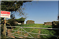
Ripe for renovation, Jawbones Hill
The sale agreed sign is beside the remains of Jawbone Barn.
Image: © Derek Harper
Taken: 13 Sep 2020
0.06 miles
3
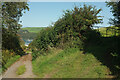
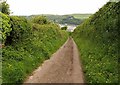
Jawbones Hill
The green lane drops past a field entrance, with a view over the Dart.
Image: © Derek Harper
Taken: 13 Sep 2020
0.11 miles
4
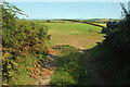
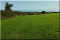
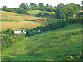
Farmland by Jawbones Hill
With a view across a side valley above Warfleet.
Image: © Derek Harper
Taken: 13 Sep 2020
0.12 miles
5
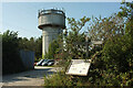
Water tower, Jawbones Hill
Together with a car park, and, next to a footpath signpost, an information board about the Diamond Jubilee Way.
Image: © Derek Harper
Taken: 13 Sep 2020
0.12 miles
6
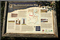
Diamond Jubilee Way
The information board shown in Image The "6km (3¾mile) way-marked circular walk, in the shape of a diamond ... " was "created to commemorate the 60th anniversary in 2012 of Her Majesty Queen Elizabeth II’s accession to the throne" https://www.southwestcoastpath.org.uk/walksdb/637/ .
Image: © Derek Harper
Taken: 13 Sep 2020
0.13 miles
7
Field by Jawbones Hill
The next field southwards to Image
Image: © Derek Harper
Taken: 13 Sep 2020
0.13 miles
8
Jawbones Hill
This green lane drops increasingly steeply into Dartmouth from Tollgate Cottage on the A379 (which takes a more circuitous route into town).
Image: © Derek Harper
Taken: 23 May 2009
0.14 miles
9
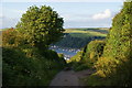
Jawbone Hill
This is one of those frustrating tracks where you know there is a good view but you can't see over the hedgerows. You can see the Dart Estuary ahead.
Image: © Bill Boaden
Taken: 22 Jun 2011
0.16 miles
10
Mesha Cottage and Jawbones barn
Taken from Fairview Road, this cottage is on the north side of Waterpool Lane. Above and slightly to the right is Jawbones barn, which is on Jawbones Hill.
Image: © jan barwick
Taken: 17 Jul 2005
0.16 miles