IMAGES TAKEN NEAR TO
Briseham Road, BRIXHAM, TQ5 9NS
Introduction
This page details the photographs taken nearby to Briseham Road, TQ5 9NS by members of the Geograph project.
The Geograph project started in 2005 with the aim of publishing, organising and preserving representative images for every square kilometre of Great Britain, Ireland and the Isle of Man.

There are currently over 7.5m images from over14,400 individuals and you can help contribute to the project by visiting https://www.geograph.org.uk
Image Map
Images are licensed for reuse under creativecommons.org/licenses/by-sa/2.0
Notes
- Clicking on the map will re-center to the selected point.
- The higher the marker number, the further away the image location is from the centre of the postcode.
Image Listing (33 Images Found)
Images are licensed for reuse under creativecommons.org/licenses/by-sa/2.0
Image
Details
Distance
1
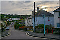
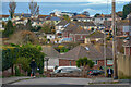
Brixham : Briseham Road
Looking along Briseham Road.
Image: © Lewis Clarke
Taken: 10 Nov 2020
0.07 miles
2
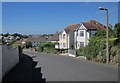
Briseham Road in Brixham
Here are several houses with mansard roofs
Image: © David Smith
Taken: 31 Aug 2012
0.09 miles
3
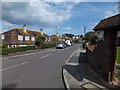
Castor Road, Brixham
Houses on the winding road through Higher Brixham.
Image: © Derek Harper
Taken: 12 Jun 2014
0.09 miles
4
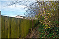
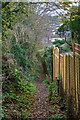
Brixham : Footpath
Looking along a footpath through Brixham.
Image: © Lewis Clarke
Taken: 10 Nov 2020
0.11 miles
5
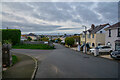
Brixham : Briseham Road
Looking along the road.
Image: © Lewis Clarke
Taken: 10 Nov 2020
0.12 miles
6

Spar shop, Castor Road, Brixham
A small shop, with an intriguing building behind. It obviously has stood here for some time, and has been modified over the years, but what was its original purpose? As a later footnote, I think that it is probably part of the West of England Steam Mills, described in 1850 as just erected at a cost of £6,000 raised by a numerous company.
Image: © David Smith
Taken: 31 Aug 2012
0.13 miles
7
Brixham : Penn Lane
Looking along Penn Lane.
Image: © Lewis Clarke
Taken: 10 Nov 2020
0.14 miles
8

Castor Road, Brixham
On the right side of the road is the Spar shown in Image, with what I think are the West of England Steam Corn Mills behind it on the right, built in 1850. The large house past the supermarket is Castor House, perhaps formerly a farmhouse, described at http://list.english-heritage.org.uk/resultsingle.aspx?uid=1208614&searchtype=mapsearch .
Image: © Derek Harper
Taken: 12 Jun 2014
0.14 miles
9
Brixham : Footpath
A footpath heads through Brixham.
Image: © Lewis Clarke
Taken: 10 Nov 2020
0.14 miles
10
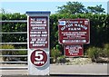
Upton Manor Farm, Brixham
"Welcome to Upton Manor Farm".
Image: © Derek Harper
Taken: 12 Jun 2014
0.14 miles