IMAGES TAKEN NEAR TO
Lakes Close, BRIXHAM, TQ5 8PJ
Introduction
This page details the photographs taken nearby to Lakes Close, TQ5 8PJ by members of the Geograph project.
The Geograph project started in 2005 with the aim of publishing, organising and preserving representative images for every square kilometre of Great Britain, Ireland and the Isle of Man.

There are currently over 7.5m images from over14,400 individuals and you can help contribute to the project by visiting https://www.geograph.org.uk
Image Map (Loading...)


Getting Data...Please wait
Leaflet Map data © OpenStreetMap
Images are licensed for reuse under creativecommons.org/licenses/by-sa/2.0
Notes
- Clicking on the map will re-center to the selected point.
- The higher the marker number, the further away the image location is from the centre of the postcode.
Image Listing (9 Images Found)
Images are licensed for reuse under creativecommons.org/licenses/by-sa/2.0
Image
Details
Distance
1
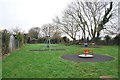
Playground - North Boundary Road
The children's playground on North Boundary Road, Brixham.
The playground is on the route of the now dismantled Torbay and Brixham Railway. The Torbay and Brixham Railway was a 7 feet 0¼ inch broad gauge railway which linked the Dartmouth and Torbay Railway at Churston railway station, Devon with the important fishing port of Brixham. It was a little over two miles long.
The railway was largely built due to the work of Richard Walter Wolston, a local solicitor, and was sold to the Great Western Railway on 1 January 1883.
Image: © Paul Hutchinson
Taken: 31 Dec 2008
0.16 miles
2
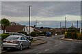
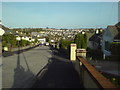
Brixham : North Boundary Road
Looking along North Boundary Road.
Image: © Lewis Clarke
Taken: 10 Nov 2020
0.17 miles
3
Brixham : Copythorne Road
Looking across Copythorne Road and beyond.
Image: © Lewis Clarke
Taken: 10 Nov 2020
0.17 miles
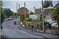
4
Brixham : Copythorne Road
Looking down the road.
Image: © Lewis Clarke
Taken: 10 Nov 2020
0.18 miles
5
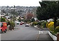
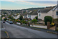
Copythorne Road, Brixham
The road drops steeply down through Brixham's suburbs to join New Road, the main road in from the west. The junction on the right is with Wayside.
Image: © Derek Harper
Taken: 23 Mar 2009
0.18 miles
6
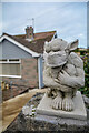
Brixham : Gargoyle
A gargoyle on Copythorne Road with a facemask.
Image: © Lewis Clarke
Taken: 10 Nov 2020
0.19 miles
7
Churston Way, Brixham
Looking down Churston Way and across the valley
Image: © Lindsey Coates
Taken: 1 Apr 2008
0.20 miles
8
Brixham : Copythorne Road
Looking up the road.
Image: © Lewis Clarke
Taken: 10 Nov 2020
0.21 miles
9
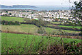
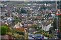
Views from Kings Barton
View of almost all of grid square SX9155 taken from the edge of the housing estate at Kings Barton looking NNE. Residential development climbs the valley out of Brixham to occupy the whole northeastern half of this grid square. Torbay and Torquay in the distance
Image: © Crispin Purdye
Taken: 16 Nov 2005
0.22 miles