IMAGES TAKEN NEAR TO
Hillrise, BRIXHAM, TQ5 0PP
Introduction
This page details the photographs taken nearby to Hillrise, TQ5 0PP by members of the Geograph project.
The Geograph project started in 2005 with the aim of publishing, organising and preserving representative images for every square kilometre of Great Britain, Ireland and the Isle of Man.

There are currently over 7.5m images from over14,400 individuals and you can help contribute to the project by visiting https://www.geograph.org.uk
Image Map
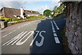
Images are licensed for reuse under creativecommons.org/licenses/by-sa/2.0
Notes
- Clicking on the map will re-center to the selected point.
- The higher the marker number, the further away the image location is from the centre of the postcode.
Image Listing (82 Images Found)
Images are licensed for reuse under creativecommons.org/licenses/by-sa/2.0
Image
Details
Distance
1
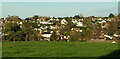
Galmpton from Dartmouth Lane
Looking right from Image], with houses between Langdon Lane and Higher Warborough Road.
Image: © Derek Harper
Taken: 25 Nov 2020
0.07 miles
2
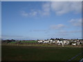
Galmpton from Dartmouth Lane
The twin hedges across the grass field are either side of Greenway Road. The houses are on the west side of the village, mostly on Hillrise. Image] looks right from here.
Image: © Derek Harper
Taken: 25 Nov 2020
0.09 miles
3
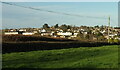
Galmpton from Greenway Road, the outskirts of the village
The open field by the Greenway Road gives a good view of the houses sitting above the Stoke Gabriel Road
Image: © Tom Jolliffe
Taken: 17 Mar 2007
0.11 miles
4
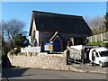
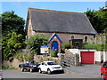
Flavel Chapel, Galmpton
The meeting place of Galmpton Congregational Evangelical Church.
This building was erected in 1870 and takes it name from John Flavel, a Puritan minister who was ejected from his parish at Dartmouth in 1662 and then preached in this locality.
Image: © Robin Drayton
Taken: 11 Jan 2012
0.11 miles
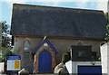
5
Flavel Chapel
Judging by the sign outside the building this chapel in Galmpton village is the site of worship for the Congregational Evangelical Church.
Image: © Tony Atkin
Taken: 16 Jul 2016
0.11 miles
6
Orange Way in Devon and Torbay (16)
The route passes the Flavel chapel.
Image: © Shazz
Taken: 16 Oct 2011
0.12 miles
7
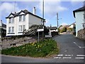
Langdon Lane, Galmpton
This road leads up to Churston Common and Windy Corner, one of the busiest junctions on the Torbay Ring Road, winter and summer.
Image: © Tom Jolliffe
Taken: 17 Mar 2007
0.13 miles
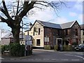
8
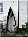
Marine Porch, Galmpton
An interesting use for part of a boat that is no longer riverworthy. Stoke Gabriel Road, Galmpton
Image: © Tom Jolliffe
Taken: 17 Mar 2007
0.13 miles
9
Stoke Gabriel Road, Galmpton
Looking West in the direction of Stoke Gabriel.
Image: © jeff collins
Taken: 22 Jul 2015
0.14 miles
10
The Manor Inn, Galmpton
A quiet backwater to stop for lunch
Image: © Tom Jolliffe
Taken: 17 Mar 2007
0.15 miles