IMAGES TAKEN NEAR TO
Hill Head Park, BRIXHAM, TQ5 0HG
Introduction
This page details the photographs taken nearby to Hill Head Park, TQ5 0HG by members of the Geograph project.
The Geograph project started in 2005 with the aim of publishing, organising and preserving representative images for every square kilometre of Great Britain, Ireland and the Isle of Man.

There are currently over 7.5m images from over14,400 individuals and you can help contribute to the project by visiting https://www.geograph.org.uk
Image Map
Images are licensed for reuse under creativecommons.org/licenses/by-sa/2.0
Notes
- Clicking on the map will re-center to the selected point.
- The higher the marker number, the further away the image location is from the centre of the postcode.
Image Listing (41 Images Found)
Images are licensed for reuse under creativecommons.org/licenses/by-sa/2.0
Image
Details
Distance
1
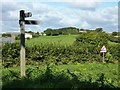
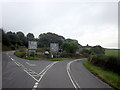
Penhill Lane, Hillhead
The footpath marker stands at the end of Penhill Lane at the junction with Slappers Hill, (the road down to the Kingswear Lower Ferry). Hillhead farm can be seen in the distance.
Image: © Tom Jolliffe
Taken: 25 Sep 2010
0.05 miles
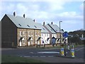
2
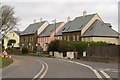
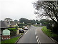
New housing, Hillhead
A view of Image from the junction of the two ferry roads - Bridge Road (foreground) and Slappers Hill (right). As well as a garage, these houses replaced a restaurant called "The Ferryman's Table" (not, I always thought, terribly convenient for the ferryman, who would have worked two miles away at the bottom of a very steep hill). The planning history of the site can be seen at http://www.southhams.gov.uk/administration/committee_agendas/development_control/08Jan03/1260.pdf .
Image: © Derek Harper
Taken: 27 Feb 2009
0.05 miles
4
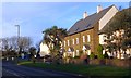
New houses, Hillhead
These houses were built within the last five years on the site of an old petrol station just before the point at which the road to Kingswear diverges to the lower of the higher ferry road across the River Dart.
Image: © Tom Jolliffe
Taken: 19 Nov 2008
0.06 miles
9
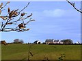
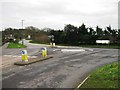
New Houses, Brixham Cross, Hillhead
A new group of houses replaced a garage which had existed at the top of the hill for many years
Image: © Tom Jolliffe
Taken: 17 Mar 2007
0.09 miles
10
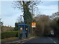
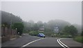
Bus shelter on Kingswear Road, Hillhead
Image: © David Smith
Taken: 11 Dec 2013
0.09 miles