IMAGES TAKEN NEAR TO
Yannons Road, PAIGNTON, TQ4 7TS
Introduction
This page details the photographs taken nearby to Yannons Road, TQ4 7TS by members of the Geograph project.
The Geograph project started in 2005 with the aim of publishing, organising and preserving representative images for every square kilometre of Great Britain, Ireland and the Isle of Man.

There are currently over 7.5m images from over14,400 individuals and you can help contribute to the project by visiting https://www.geograph.org.uk
Image Map
Images are licensed for reuse under creativecommons.org/licenses/by-sa/2.0
Notes
- Clicking on the map will re-center to the selected point.
- The higher the marker number, the further away the image location is from the centre of the postcode.
Image Listing (71 Images Found)
Images are licensed for reuse under creativecommons.org/licenses/by-sa/2.0
Image
Details
Distance
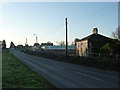
1

Roselands Drive, Ring Road Paignton, land clearance
The land opposite Roselands Drive is being cleared for redevelopment. A house which has been obscured by a high hedgerow for decades has emerged into view. This is in the distance in this photograph.
Image: © Tom Jolliffe
Taken: 26 Feb 2012
0.02 miles
2
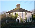
Derelict House, Ring Road, Paignton
The derelict house has become visible during land clearance for redevelopment opposite the Roselands estate.
Image: © Tom Jolliffe
Taken: 26 Feb 2012
0.02 miles
3
Derelict House, Ring Road, Paignton
The derelict house is opposite the Roselands estate.
Image: © Tom Jolliffe
Taken: 26 Feb 2012
0.02 miles
4
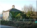
Derelict House, Ring Road, Paignton
The rear of the derelict house reveals an outbuilding covered in ivy which has been gradually falling into decline over decades hidden behind the high hedges which have now been cut back. There are a few houses like this positioned on the Ring Road. They were built long before the age of holiday camps brought visitors flocking to Brixham.
Image: © Tom Jolliffe
Taken: 26 Feb 2012
0.02 miles
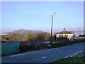
5
Ring Road, Paignton
The solitary derelict house stands next to the Ring Road near to Roselands Drive. One can perhaps get a sense of what this road once looked like when the area was much less populated. This area will soon be redeveloped.
Image: © Tom Jolliffe
Taken: 26 Feb 2012
0.03 miles
6

Houses by Fusion, Paignton
Bungalows between the one shown in Image] and the A3022 Brixham Road.
Image: © Derek Harper
Taken: 30 Aug 2018
0.03 miles
7

Entrance road, Aldi
With a banner advert for Cavanna Home. Across the A3022 is housing on the Roselands estate.
Image: © Derek Harper
Taken: 30 Aug 2018
0.03 miles
8

New housing development
Located close to the new Aldi supermarket alongside Brixham Road.
Image: © Richard Dorrell
Taken: 15 Sep 2015
0.03 miles
9
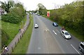
Brixham Road, inner ring road, dangerous for cyclists
This road was described as the most dangerous road in the world for cyclists by an eminent local cyslist. It is good to see that provision is being made for pedestrians and for cyclists, however patchy and interrupted. The rationale for supporting cyclists includes the cost of petrol which can be seen in this picture as £1.17 a litre for non-leaded. The Torbay area is somewaht challenging for cyclists as it is quite hilly.
Image: © Tom Jolliffe
Taken: 5 May 2010
0.03 miles
10

Aldi, Paignton
The store is beside the A3022 Brixham Road (visible between the car park ahead and the trees); it opened in 2016.
Image: © Derek Harper
Taken: 30 Aug 2018
0.04 miles