IMAGES TAKEN NEAR TO
Clover Close, PAIGNTON, TQ4 7SY
Introduction
This page details the photographs taken nearby to Clover Close, TQ4 7SY by members of the Geograph project.
The Geograph project started in 2005 with the aim of publishing, organising and preserving representative images for every square kilometre of Great Britain, Ireland and the Isle of Man.

There are currently over 7.5m images from over14,400 individuals and you can help contribute to the project by visiting https://www.geograph.org.uk
Image Map (Loading...)


Getting Data...Please wait
Leaflet Map data © OpenStreetMap
Images are licensed for reuse under creativecommons.org/licenses/by-sa/2.0
Notes
- Clicking on the map will re-center to the selected point.
- The higher the marker number, the further away the image location is from the centre of the postcode.
Image Listing (57 Images Found)
Images are licensed for reuse under creativecommons.org/licenses/by-sa/2.0
Image
Details
Distance
1
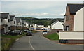
Clover Close, Fusion development
The road is also shown in Image At the bottom is a pair of dry mortar silos on the building site on Foxglove Way.
Image: © Derek Harper
Taken: 30 Aug 2018
0.02 miles
2
Clover Close, Fusion development
A reverse view of Image] from the junction with Foxglove Way.
Image: © Derek Harper
Taken: 30 Aug 2018
0.02 miles
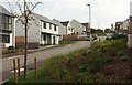
3
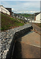
New housing, Paignton
A gabion at the top of Clover Close, a new road of houses on the Fusion development.
Image: © Derek Harper
Taken: 30 Aug 2018
0.03 miles
4

Foxglove Way, Fusion development
A reverse view of Image, with houses facing downhill across the construction site.
Image: © Derek Harper
Taken: 30 Aug 2018
0.03 miles
5
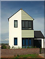
House on Hollyhock Way, Paignton
The house at the west end of Hollyhock Way.
Image: © Derek Harper
Taken: 30 Aug 2018
0.04 miles
6
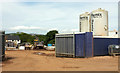
Dry mortar silos, Fusion development
On the current building site on Foxglove Way.
Image: © Derek Harper
Taken: 30 Aug 2018
0.04 miles
7
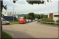
Fusion development, Paignton
Wilkins Drive passes the turning left into Foxglove Way. On the left is the construction site shown in Image; on the right is Torbay Pharmaceuticals.
Image: © Derek Harper
Taken: 30 Aug 2018
0.04 miles
8
Hollyhock Way, Fusion development
The northern edge of the new housing, with a bank covered in wild flowers on the left, and a mysterious slated-walled structure on top of the bank above Clover Close.
Image: © Derek Harper
Taken: 30 Aug 2018
0.04 miles
9
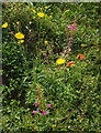
Flowers, Fusion, Paignton
From the path shown in Image The flowers, including rosebay willowhwrb, poppies and sow-thistle, appear to be self-sown; all favour disturbed ground.
Image: © Derek Harper
Taken: 30 Aug 2018
0.06 miles
10

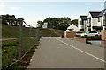
Path, road, houses on Fusion
On the southern edge of the Fusion develiopment, with Hollyhock Way on the left. The path leads around to the junction in Image
Image: © Derek Harper
Taken: 30 Aug 2018
0.07 miles