IMAGES TAKEN NEAR TO
Goodrington Road, PAIGNTON, TQ4 7JD
Introduction
This page details the photographs taken nearby to Goodrington Road, TQ4 7JD by members of the Geograph project.
The Geograph project started in 2005 with the aim of publishing, organising and preserving representative images for every square kilometre of Great Britain, Ireland and the Isle of Man.

There are currently over 7.5m images from over14,400 individuals and you can help contribute to the project by visiting https://www.geograph.org.uk
Image Map
Images are licensed for reuse under creativecommons.org/licenses/by-sa/2.0
Notes
- Clicking on the map will re-center to the selected point.
- The higher the marker number, the further away the image location is from the centre of the postcode.
Image Listing (4 Images Found)
Images are licensed for reuse under creativecommons.org/licenses/by-sa/2.0
Image
Details
Distance
1
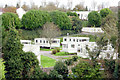
Another Caravan Park, Goodrington
This Park, off Grange Road, Goodrington, is set in amongst residential development
Image: © Crispin Purdye
Taken: 16 Nov 2005
0.12 miles
2
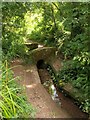
Bridge on Roselands Road
This public footpath, here crossing a tiny brook, is shown as a road on old maps. The path connects the Roselands estate with Grange Road at Goodrington via pleasant open fields.
Image: © Derek Harper
Taken: 1 Aug 2008
0.23 miles
3
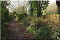
Roselands Road, Goodrington
Further west along footpath PN3 from where Image] was taken.
Image: © Derek Harper
Taken: 6 Apr 2019
0.23 miles
4
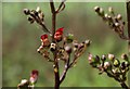
Common figwort
Scrophularia nodosa is an impressively tall if rather gawky plant, and its flowers are tiny, but a beautiful colour. Here it is growing in damp conditions in the valley of the stream shown in Image
Image: © Derek Harper
Taken: 1 Aug 2008
0.25 miles