IMAGES TAKEN NEAR TO
Harberton Close, PAIGNTON, TQ4 7EA
Introduction
This page details the photographs taken nearby to Harberton Close, TQ4 7EA by members of the Geograph project.
The Geograph project started in 2005 with the aim of publishing, organising and preserving representative images for every square kilometre of Great Britain, Ireland and the Isle of Man.

There are currently over 7.5m images from over14,400 individuals and you can help contribute to the project by visiting https://www.geograph.org.uk
Image Map
Images are licensed for reuse under creativecommons.org/licenses/by-sa/2.0
Notes
- Clicking on the map will re-center to the selected point.
- The higher the marker number, the further away the image location is from the centre of the postcode.
Image Listing (67 Images Found)
Images are licensed for reuse under creativecommons.org/licenses/by-sa/2.0
Image
Details
Distance
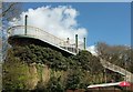
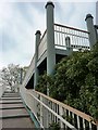
1

Footbridge, Brixham Road
The footbridge is a substantial construction and reaches quite height over the main Brixham road. Houses in the Roselands estate can be seen in the background.
Image: © Tom Jolliffe
Taken: 5 May 2010
0.03 miles
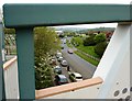
2
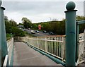
Footbridge, Brixham Road, looking south
This footbridge crosses the main ring road which carries very large volumes of traffic every day and even more in the holiday season.
Image: © Tom Jolliffe
Taken: 5 May 2010
0.03 miles
3
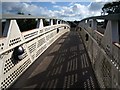
Footbridge across A3022
The footbridge links Sainsbury's to the Roselands estate across Brixham Road.
Image: © Derek Harper
Taken: 21 Aug 2008
0.04 miles
4
Footbridge, Brixham Road
Graffiti has been sprayed onto the bridge, indecipherable to me. In the distance cam be seen a hill next to the Totnes Road. A man wheeling a bicycle asked me if I knew who owned the bridge as his job was to remove the graffiti and the local council did not know!
Image: © Tom Jolliffe
Taken: 5 May 2010
0.04 miles
6
Footbridge across A3022
Also shown at http://www.geograph.org.uk/search.php?i=62772273 , but not this view from the Saunsbury's car park.
Image: © Derek Harper
Taken: 26 Apr 2016
0.05 miles
7
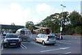
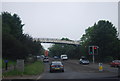
Car Park at Tesco Paignton
View north across the car park. In the distance can be seen the ramps of the footbridge across the Brixham Rd, the A3022.
Image: © Nigel Mykura
Taken: 11 Jun 2022
0.05 miles
8
Through the bridge, Brixham Road
The passer-by asked, "What is there to photograph on this bridge? Are you taking photographs of graffiti?" A good question, which received an honest answer which seemed to satisfy my interrogator, whose job it was to remove graffiti. Are these municipal colours designed to be largely inoffensive and to blend into the background? It is a relatively large structure, though, and not easy to hide. Here we spy on the traffic making its way out of Brixham on the ring road.
Image: © Tom Jolliffe
Taken: 5 May 2010
0.05 miles
9
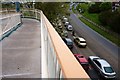
Two worlds, by foot and by car, Brixham Road
The footbridge is little used, but very necessary for pedestrians nonetheless. The Brixham Road has been widened at this point and there is always a heavy volume of traffic. From this point the two distinctive worlds of the pedestrian and the motorist are sharply contrasted. The pedestrian can proceed unhindreed at will, the motorist is cheek by jowl and jockeying for position.
Image: © Tom Jolliffe
Taken: 5 May 2010
0.05 miles
10
Footbridge over Brixham Road to Harberton Close
The footbridge was constructed when Plymco was allowed to build a supermarket on the site. This footbridge gives pedestrian access from the Roselands housing estate to the supermarket. The site was bought by Sainsbury's from Plymco over ten years ago, presumably because it was not achieving for Plymco what was expected.
Image: © Tom Jolliffe
Taken: 5 May 2010
0.05 miles