IMAGES TAKEN NEAR TO
Seafields, PAIGNTON, TQ4 6NZ
Introduction
This page details the photographs taken nearby to Seafields, TQ4 6NZ by members of the Geograph project.
The Geograph project started in 2005 with the aim of publishing, organising and preserving representative images for every square kilometre of Great Britain, Ireland and the Isle of Man.

There are currently over 7.5m images from over14,400 individuals and you can help contribute to the project by visiting https://www.geograph.org.uk
Image Map
Images are licensed for reuse under creativecommons.org/licenses/by-sa/2.0
Notes
- Clicking on the map will re-center to the selected point.
- The higher the marker number, the further away the image location is from the centre of the postcode.
Image Listing (115 Images Found)
Images are licensed for reuse under creativecommons.org/licenses/by-sa/2.0
Image
Details
Distance
1
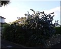
Ceanothus, Dartmouth Road, Three Beaches, Waterside
The ceanothus has grown well here in the South Devon climate and is in full flower. There are many different varieties. They were often referred to by Raymond Chandler in his "noirish" private detective stories, such as "The Big Sleep". This is not "Bay City" however, but Torbay, as evidenced by the palm leaves creeping into the top of the picture.
Image: © Tom Jolliffe
Taken: 3 May 2009
0.01 miles
2
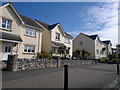
Dartmouth Road, Goodrington
Suburban homes on Dartmouth Road - close to the junction with Seafields - in the Goodrington area of Paignton, Devon, England.
Image: © Steven Haslington
Taken: 17 Sep 2012
0.02 miles
3

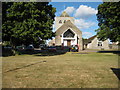
St George's Church and Goodrington
The white tower of St George's Church at Three Beaches is prominent in this picture. Behind it lies the promenade at the end of Goodrington beach and beyond that, Torquay.
Image: © Tom Jolliffe
Taken: 29 Oct 2013
0.03 miles
4
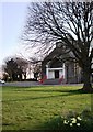
St George's Church, Three Beaches, Paignton
St George's Church is somewhat unprepossessing from outside, being rendered with cement mortar. The tree and the daffodils provide a pleasant foreground.
Image: © Tom Jolliffe
Taken: 21 Mar 2010
0.04 miles
5
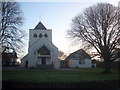
St George's Church in Dartmouth Road Goodrington
Image: © Rod Allday
Taken: 22 Jan 2014
0.04 miles
7
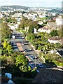
Dartmouth Road, close to Three Beaches
The dual carriageway ends as it approaches Three Beaches and Goodrington. It was built in the days when the needs of the car driver were the guiding principle of all road construction. This road was driven through a solid cliff to make the progress from Paignton to Brixham easier and swifter. Much has changed and today's climate of traffic management sees one of the two lanes on each side totally closed to cars, allowing only buses and bicycles and a speed limit overall of 30 mph. Bravo!
Image: © Tom Jolliffe
Taken: 29 Oct 2013
0.06 miles
8
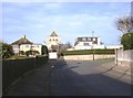
Oyster Bend, Goodrington. St George's Church
Residential area behind Three Beaches shops with the tower of St George's church the dominant feature.
Image: © Tom Jolliffe
Taken: 11 Mar 2007
0.06 miles
9
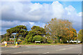
Goodrington Road
Road junction in Goodrington.
Image: © Wayland Smith
Taken: 16 Oct 2021
0.07 miles
