IMAGES TAKEN NEAR TO
Oyster Close, PAIGNTON, TQ4 6NN
Introduction
This page details the photographs taken nearby to Oyster Close, TQ4 6NN by members of the Geograph project.
The Geograph project started in 2005 with the aim of publishing, organising and preserving representative images for every square kilometre of Great Britain, Ireland and the Isle of Man.

There are currently over 7.5m images from over14,400 individuals and you can help contribute to the project by visiting https://www.geograph.org.uk
Image Map
Images are licensed for reuse under creativecommons.org/licenses/by-sa/2.0
Notes
- Clicking on the map will re-center to the selected point.
- The higher the marker number, the further away the image location is from the centre of the postcode.
Image Listing (151 Images Found)
Images are licensed for reuse under creativecommons.org/licenses/by-sa/2.0
Image
Details
Distance
1
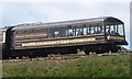
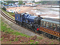
Pullman car, Goodrington
At the rear of the service shown in Image], this Pullman observation car carries the label "Devon Belle" http://en.wikipedia.org/wiki/Devon_Belle .
Image: © Derek Harper
Taken: 12 May 2014
0.01 miles
3
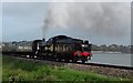
7827 Lydham Manor leaving Goodrington, Paignton
7829 Lydham Manor climbing away from Goodrington Station, Paignton and heading to Kingswear.
GWR Class 7800, designed by Collett. Built in Swindon. Wt. = 68tons 18 cwt. Driving Wheel dia. 5'8" 4-6-0. Withdrawn from BR in October 1965.
Now preserved and shown on the Paignton-Dartmouth Railway. In December 2017 7829 was showing the BR black livery.
Image: © John C
Taken: 16 Dec 2017
0.03 miles
5
Steam train and Goodrington Sands
The Paignton & Kingswear Railway runs past the expanse of Goodrington Sands. The locomotive is Great Western Railway No. 6023 King Edward II in experimental BR blue. This is a Marmite livery but I like it. The observation car is an extra fee to ride but is best enjoyed without the bulk of a 'King' in the way.
Image: © Chris Allen
Taken: 2 Sep 2018
0.04 miles
6
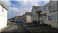
South Sands
Short private cul-de-sac off Cliff Park Road. Some of the houses here will have views over Goodrington Sands.
Image: © Richard Dorrell
Taken: 9 Apr 2019
0.05 miles
7
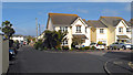
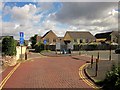
Cliff Park Road
The turning on the right is Beach Walk - slightly misleadingly named, as it does not lead to the beach, but is a residential cul-de-sac. The road on the left is Cliff Park Road, which is also a cul-de-sac, and does indeed lead to the beach.
Image: © Richard Dorrell
Taken: 9 Apr 2019
0.05 miles
8
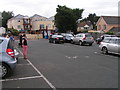
Car park on Cliff Park Road, Goodrington
Image: © Rob Purvis
Taken: 23 Aug 2012
0.05 miles
9
Car park, Cliff Park Road, Goodrington
Another view of the car park shown in Image The modern house behind are in a cul-de-sac, Beach Walk.
Image: © Derek Harper
Taken: 12 May 2014
0.05 miles
10
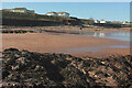
Rocks, Goodrington Sands South #5
Looking behind the camera from Image In the centre, the railway line crosses the end of Cliff Park Road, with Cliff Park Court beside it. On the right are public conveniences.
Image: © Derek Harper
Taken: 28 Feb 2021
0.05 miles