IMAGES TAKEN NEAR TO
Sands Road, PAIGNTON, TQ4 6HB
Introduction
This page details the photographs taken nearby to Sands Road, TQ4 6HB by members of the Geograph project.
The Geograph project started in 2005 with the aim of publishing, organising and preserving representative images for every square kilometre of Great Britain, Ireland and the Isle of Man.

There are currently over 7.5m images from over14,400 individuals and you can help contribute to the project by visiting https://www.geograph.org.uk
Image Map
Images are licensed for reuse under creativecommons.org/licenses/by-sa/2.0
Notes
- Clicking on the map will re-center to the selected point.
- The higher the marker number, the further away the image location is from the centre of the postcode.
Image Listing (428 Images Found)
Images are licensed for reuse under creativecommons.org/licenses/by-sa/2.0
Image
Details
Distance
1
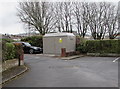
Sands Court electricity substation, Paignton
The grey cabinet is a Western Power Distribution electricity substation set back 30 metres from Sands Road at the edge of Sands Court flats. The substation identifier is SANDS COURT 34-3956.
Image: © Jaggery
Taken: 2 Apr 2018
0.01 miles
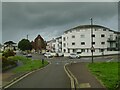
2
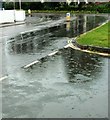
It rained and it rained
Virtually end-to-end rain in South Devon; seen here is the B3201 Sands Road bending to meet Whitstone Road with, in the foreground, the turning into Sands Court.
Image: © Derek Harper
Taken: 21 Jul 2017
0.01 miles
3
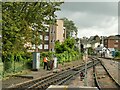
Switching tracks at Paignton Queens Park station
Workers of the Dartmouth Steam Railway operating a manual points mechanism or 'ground frame'.
Image: © Stephen Craven
Taken: 12 Jul 2021
0.02 miles
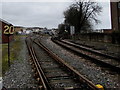
4
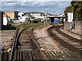
Railway tracks, Paignton
A view from the level crossing on Sands Road. A distinction is made between the main line Paignton station to the left, and Queen's Park station on the right, northern terminus of the Paignton & Dartmouth Steam Railway.
Image: © Derek Harper
Taken: 21 Oct 2010
0.02 miles
5
Sands Road, Paignton
Viewed from a train traversing the level crossing. In the distance is St Andrew's church Image
Image: © Stephen Craven
Taken: 12 Jul 2021
0.02 miles
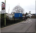
6
20 speed limit sign on the approach to Paignton railway station
Viewed looking north from Sands Road level crossing. https://www.geograph.org.uk/photo/6096894
Image: © Jaggery
Taken: 2 Apr 2018
0.02 miles
7
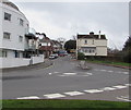
Mini-roundabout at the junction of Sands Road and Whitstone Road, Paignton
Looking south along Whitstone Road.
Image: © Jaggery
Taken: 2 Apr 2018
0.03 miles
8
Warning sign - level crossing, Station Lane, Paignton
On the approach to Sands Road level crossing. https://www.geograph.org.uk/photo/6096894
Image: © Jaggery
Taken: 2 Apr 2018
0.03 miles
9
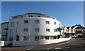
Tor Sands
The buildings contains 23 flats, and stands beside a miniroundabout at the junction of Sands Road and Whitstone Road (right).
Image: © Derek Harper
Taken: 21 Oct 2010
0.03 miles
10
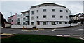
Tor Sands, Paignton
Flats on the corner of Sands Road and Whitstone Road.
Image: © Jaggery
Taken: 2 Apr 2018
0.03 miles