IMAGES TAKEN NEAR TO
St. Michaels Road, PAIGNTON, TQ4 5LR
Introduction
This page details the photographs taken nearby to St. Michaels Road, TQ4 5LR by members of the Geograph project.
The Geograph project started in 2005 with the aim of publishing, organising and preserving representative images for every square kilometre of Great Britain, Ireland and the Isle of Man.

There are currently over 7.5m images from over14,400 individuals and you can help contribute to the project by visiting https://www.geograph.org.uk
Image Map (Loading...)


Getting Data...Please wait
Leaflet Map data © OpenStreetMap
Images are licensed for reuse under creativecommons.org/licenses/by-sa/2.0
Notes
- Clicking on the map will re-center to the selected point.
- The higher the marker number, the further away the image location is from the centre of the postcode.
Image Listing (41 Images Found)
Images are licensed for reuse under creativecommons.org/licenses/by-sa/2.0
Image
Details
Distance
1
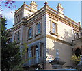
Tower House School, Paignton
The school is in Fisher Street. See its website http://www.towerhouseschool.co.uk/
Image: © Jennifer Vaughan
Taken: 7 Sep 2006
0.06 miles
2
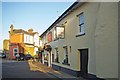
The Torbay Inn
The oldest pub in Paignton Stands on the corner of St Michaels Rd and Fisher St http://www.torbayinn.co.uk/
Image: © Glyn Baker
Taken: 29 Mar 2012
0.11 miles
3
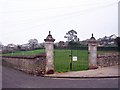
Park gates
This small park in Derrell Road is partly enclosed by an old wall with these unexpectedly ornate gate posts.
Image: © Richard Dorrell
Taken: 1 Jan 2009
0.13 miles
4
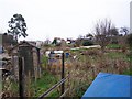
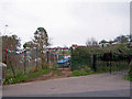
Derrell Road allotments
On the gate to the allotments, the name of the road is mis-spelt 'Derrel'.
Image: © Richard Dorrell
Taken: 1 Jan 2009
0.14 miles
5
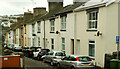
Elmbank Road, Paignton
Terraced houses line the street leading down from the Totnes Road.
Image: © Derek Harper
Taken: 13 Oct 2023
0.14 miles
6
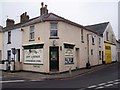
Corner shop
This shop stands on the corner of Hayes Road and Derrell Road, directly opposite the Devonport Arms public house.
Image: © Richard Dorrell
Taken: 1 Jan 2009
0.14 miles
7
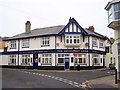
The Devonport Arms
A large public house on the corner Hayes Road and Elmbank Road.
Image: © Richard Dorrell
Taken: 1 Jan 2009
0.14 miles
8
Contrasting entrance gates
The gate on the left is an entrance to the Derrell Road allotments.
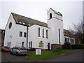
The black and gold gates on the right are the entrance to the Kingdom Hall of Jehovah's Witnesses.
Image: © Richard Dorrell
Taken: 1 Jan 2009
0.15 miles
9
St Michael's Court
Renovated in 1985, this former church and flats behind it are now sheltered homes for the elderly managed by Guinness Care and Support Ltd.
Image: © Richard Dorrell
Taken: 1 Jan 2009
0.17 miles
10
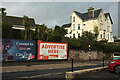
Hoardings and houses, Totnes Road, Paignton
Seen across the A3022. On the right above the advertising hoardings is a pair of semis which front the other way onto Primley Park. Some of the New Zealand cabbage trees seem to be flowering in October rather than early summer. Another sign of global warming?
Image: © Derek Harper
Taken: 13 Oct 2023
0.17 miles