IMAGES TAKEN NEAR TO
Dartmouth Road, PAIGNTON, TQ4 5AL
Introduction
This page details the photographs taken nearby to Dartmouth Road, TQ4 5AL by members of the Geograph project.
The Geograph project started in 2005 with the aim of publishing, organising and preserving representative images for every square kilometre of Great Britain, Ireland and the Isle of Man.

There are currently over 7.5m images from over14,400 individuals and you can help contribute to the project by visiting https://www.geograph.org.uk
Image Map
Images are licensed for reuse under creativecommons.org/licenses/by-sa/2.0
Notes
- Clicking on the map will re-center to the selected point.
- The higher the marker number, the further away the image location is from the centre of the postcode.
Image Listing (385 Images Found)
Images are licensed for reuse under creativecommons.org/licenses/by-sa/2.0
Image
Details
Distance
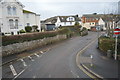
2
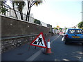
Paignton : Dartmouth Road & Roadworks
A sign and traffic lights ahead where roadworks are.
Image: © Lewis Clarke
Taken: 16 Jun 2010
0.03 miles
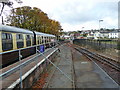
6
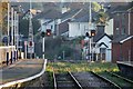
Level Crossing, Paignton
The level crossing at the south end of Paignton station
Image: © Rob Newman
Taken: 28 Sep 2011
0.05 miles
7
South along Station Lane, Paignton
From Great Western Road along Station Lane towards Sands Road.
Paignton Library and Information Centre https://www.geograph.org.uk/photo/5779045 is on the left.
Image: © Jaggery
Taken: 2 Apr 2018
0.05 miles
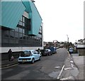
9
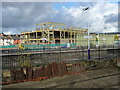
Paignton - Building Site
Construction site across from therailway station.
Image: © Chris Talbot
Taken: 21 Oct 2009
0.05 miles
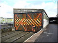
10
Paignton - Railway Line
This line leads to Dartmouth.
Image: © Chris Talbot
Taken: 21 Oct 2009
0.05 miles