IMAGES TAKEN NEAR TO
Queen Elizabeth Drive, PAIGNTON, TQ3 3YS
Introduction
This page details the photographs taken nearby to Queen Elizabeth Drive, TQ3 3YS by members of the Geograph project.
The Geograph project started in 2005 with the aim of publishing, organising and preserving representative images for every square kilometre of Great Britain, Ireland and the Isle of Man.

There are currently over 7.5m images from over14,400 individuals and you can help contribute to the project by visiting https://www.geograph.org.uk
Image Map
Images are licensed for reuse under creativecommons.org/licenses/by-sa/2.0
Notes
- Clicking on the map will re-center to the selected point.
- The higher the marker number, the further away the image location is from the centre of the postcode.
Image Listing (16 Images Found)
Images are licensed for reuse under creativecommons.org/licenses/by-sa/2.0
Image
Details
Distance
1
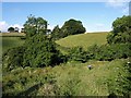
Valley, Great Parks
Looking across the valley from near an access point from Great Parks Lane to the footpath. The information board by the path explains about wildlife to be found in the area.
Image: © Derek Harper
Taken: 19 Jun 2008
0.09 miles
2
Footpath in Great Parks
The small brook is a popular playing place for children in the summer.
Image: © Richard Dorrell
Taken: 29 Dec 2008
0.18 miles
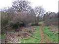
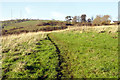
3
Footpath, Great Parks
The footpath from Great Parks Road follows the Clennon stream valley upstream.
Image: © Derek Harper
Taken: 19 Jun 2008
0.18 miles
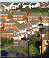
4
Houses on Highfield Crescent, Paignton
Bits of them, anyway. Highfield Crescent, like many other roads in suburban Torbay, is prodigiously steep.
Image: © Derek Harper
Taken: 14 Aug 2018
0.19 miles
5
1990's housing development
Modern housing at former Great Parks Farm, off the Torbay ring road
Image: © Crispin Purdye
Taken: 17 Nov 2005
0.19 miles
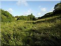
6
Footpath near Naptor
Footpath adjacent to the Great Parks farm housing development. Beacon Hill in the distance
Image: © Crispin Purdye
Taken: 17 Nov 2005
0.20 miles
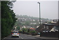
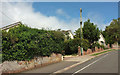
8
Going down the steep hill on King's Ash Road
Image: © Rob Purvis
Taken: 4 Jul 2022
0.21 miles
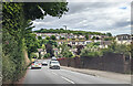
9
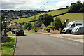
Highfield Crescent, Paignton
Looking down the hill from where Image] was taken, with farmland across the valley. In the distance, traffic can be seen queuing on the Brixham Road.
Image: © Derek Harper
Taken: 14 Aug 2018
0.22 miles
10
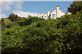
Houses above Great Parks valley
Thick vegetation beside Image] on the valley side, with detached houses shown from the other direction in Image
Image: © Derek Harper
Taken: 14 Aug 2018
0.22 miles