IMAGES TAKEN NEAR TO
Kings Ash Road, PAIGNTON, TQ3 3TU
Introduction
This page details the photographs taken nearby to Kings Ash Road, TQ3 3TU by members of the Geograph project.
The Geograph project started in 2005 with the aim of publishing, organising and preserving representative images for every square kilometre of Great Britain, Ireland and the Isle of Man.

There are currently over 7.5m images from over14,400 individuals and you can help contribute to the project by visiting https://www.geograph.org.uk
Image Map
Images are licensed for reuse under creativecommons.org/licenses/by-sa/2.0
Notes
- Clicking on the map will re-center to the selected point.
- The higher the marker number, the further away the image location is from the centre of the postcode.
Image Listing (35 Images Found)
Images are licensed for reuse under creativecommons.org/licenses/by-sa/2.0
Image
Details
Distance
1
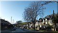
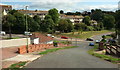
A380, King's Ash Road
Houses lining this road, part of the route taken by traffic bypassing Torbay. On the left is the end of Colley End Road.
Image: © David Smith
Taken: 26 Dec 2013
0.02 miles
2
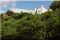
Houses on Highfield Crescent, Paignton
Bits of them, anyway. Highfield Crescent, like many other roads in suburban Torbay, is prodigiously steep.
Image: © Derek Harper
Taken: 14 Aug 2018
0.08 miles
3
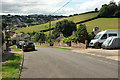
Highfield Crescent, Paignton
Looking down the hill from where Image] was taken, with farmland across the valley. In the distance, traffic can be seen queuing on the Brixham Road.
Image: © Derek Harper
Taken: 14 Aug 2018
0.09 miles
4
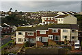
1970's development, Paignton
Housing above the Torbay ring road between Colley End Road and Waterleat Road. View to the north with Windmill Hill in the centre background
Image: © Crispin Purdye
Taken: 15 Nov 2005
0.10 miles
5
Houses above Great Parks valley
Thick vegetation beside Image] on the valley side, with detached houses shown from the other direction in Image
Image: © Derek Harper
Taken: 14 Aug 2018
0.10 miles
6
Footpath in Great Parks
The footpath runs close to the Clennon Stream which follows a line of trees.
The oak tree in this picture still looks autumnal in spite of this being the end of December.
Image: © Richard Dorrell
Taken: 29 Dec 2008
0.11 miles
7
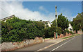
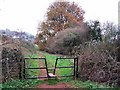
Gates, Highfield Crescent, Paignton
The nearer gate leads onto footpath PN 5. The further one leads into bracken and brambles. But it has a dropped pavement so has been intended for vehicles.
Image: © Derek Harper
Taken: 14 Aug 2018
0.11 miles
8
King's Ash Cross
Highfield Crescent plunges down to the slightly offset crossroads with the A380 King's Ash Road. On the other side is Foxhole Road.
Image: © Derek Harper
Taken: 14 Aug 2018
0.11 miles
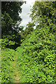
9
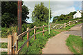
Footpath to Highfield Crescent, Paignton
A reverse view of Image] as footpath PN 5 reaches the suburban road.
Image: © Derek Harper
Taken: 14 Aug 2018
0.11 miles
10
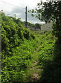
Footpath, Great Parks valley
Footpath PN 5 just past the gate on the left of Image
Image: © Derek Harper
Taken: 14 Aug 2018
0.11 miles