IMAGES TAKEN NEAR TO
Marldon Road, PAIGNTON, TQ3 3NW
Introduction
This page details the photographs taken nearby to Marldon Road, TQ3 3NW by members of the Geograph project.
The Geograph project started in 2005 with the aim of publishing, organising and preserving representative images for every square kilometre of Great Britain, Ireland and the Isle of Man.

There are currently over 7.5m images from over14,400 individuals and you can help contribute to the project by visiting https://www.geograph.org.uk
Image Map
Images are licensed for reuse under creativecommons.org/licenses/by-sa/2.0
Notes
- Clicking on the map will re-center to the selected point.
- The higher the marker number, the further away the image location is from the centre of the postcode.
Image Listing (49 Images Found)
Images are licensed for reuse under creativecommons.org/licenses/by-sa/2.0
Image
Details
Distance
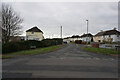
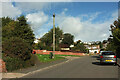
4
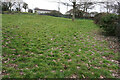
Turf zone SmallRedwell
Small green next to Redwell Lane, Foxhole.
Image: © Ian S
Taken: 11 Feb 2023
0.08 miles
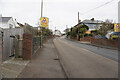
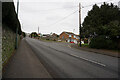
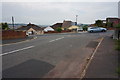
6
Road junction, Foxhole
Foxhole Road drops down to the left from Smallcombe Road.
Image: © Derek Harper
Taken: 19 Jun 2008
0.10 miles
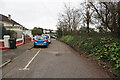
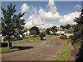
8
Redwell Road, Paignton
Passing Overclose on the left.
Image: © Derek Harper
Taken: 7 Oct 2022
0.11 miles
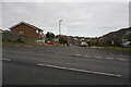
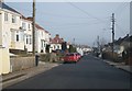
9
Road junction, Paignton
The junction of Lammas Lane with Maidenway Road.
Image: © jeff collins
Taken: 31 May 2014
0.11 miles