IMAGES TAKEN NEAR TO
Blagdon Road, PAIGNTON, TQ3 3FZ
Introduction
This page details the photographs taken nearby to Blagdon Road, TQ3 3FZ by members of the Geograph project.
The Geograph project started in 2005 with the aim of publishing, organising and preserving representative images for every square kilometre of Great Britain, Ireland and the Isle of Man.

There are currently over 7.5m images from over14,400 individuals and you can help contribute to the project by visiting https://www.geograph.org.uk
Image Map
Images are licensed for reuse under creativecommons.org/licenses/by-sa/2.0
Notes
- Clicking on the map will re-center to the selected point.
- The higher the marker number, the further away the image location is from the centre of the postcode.
Image Listing (15 Images Found)
Images are licensed for reuse under creativecommons.org/licenses/by-sa/2.0
Image
Details
Distance
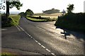
1
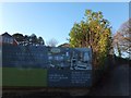
Development in the countryside
Where the poster is, there once was greenery. The site was a manor house, and the website tells us that it is "A perfect destination for holiday homes(sic)"
Image: © David Smith
Taken: 26 Dec 2013
0.07 miles
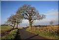
2
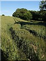
Wheatfield, Glazegate Cross
Tramlines run parallel to Blagdon Road (on the right) along the edge of this field of wheat on the uplands between Marldon and Berry Pomeroy.
Image: © Derek Harper
Taken: 10 Jun 2008
0.08 miles
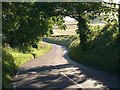
3
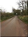
Blagdon Road
Heading Southeast, away from Glazegate Cross.
Image: © jeff collins
Taken: 7 Nov 2020
0.09 miles
4
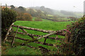
Leaning gate, Hunter's Court
On West Lane, and offering a rather misty view to Beacon Hill.
Image: © Derek Harper
Taken: 22 Nov 2020
0.10 miles
5
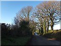
Trees lining Blagdon Road
The trees on the left are at the top of a small wood on the banks of a stream which rises close to the road and flows into the Dart at Fleet Mill Image
Image: © David Smith
Taken: 26 Dec 2013
0.10 miles
6
Totnes Road approaching Glazegate Cross
The well-used road between Marldon and Berry Pomeroy drops around bends between banks.
Image: © Derek Harper
Taken: 10 Jun 2008
0.11 miles
7
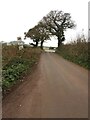
Blagdon Road
Seen here approaching Glazegate Cross.
Image: © jeff collins
Taken: 7 Nov 2020
0.14 miles
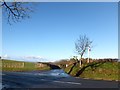
8
Crossroads ahead
Looking towards the road junction with Berry Pomeroy towards the left. this view is taken from the lane that approaches from Blagdon village.
Image: © roger geach
Taken: 16 Dec 2009
0.15 miles
9
Glazegate Cross
Another view of Image, which is named Glazegate Cross on the maps, taken much later in the day. In the background is Blackpool Clump.
Image: © Derek Harper
Taken: 10 Jun 2008
0.16 miles
10
Glazegate Cross
The crossroads is where Blagdon Road from Collaton St Mary meets the Totnes Road. Opposite, on the left, the stone wall under the "hedge" is exposed by the gateway.
Image: © David Smith
Taken: 26 Dec 2013
0.16 miles