IMAGES TAKEN NEAR TO
Well Street, PAIGNTON, TQ3 3AL
Introduction
This page details the photographs taken nearby to Well Street, TQ3 3AL by members of the Geograph project.
The Geograph project started in 2005 with the aim of publishing, organising and preserving representative images for every square kilometre of Great Britain, Ireland and the Isle of Man.

There are currently over 7.5m images from over14,400 individuals and you can help contribute to the project by visiting https://www.geograph.org.uk
Image Map
Images are licensed for reuse under creativecommons.org/licenses/by-sa/2.0
Notes
- Clicking on the map will re-center to the selected point.
- The higher the marker number, the further away the image location is from the centre of the postcode.
Image Listing (217 Images Found)
Images are licensed for reuse under creativecommons.org/licenses/by-sa/2.0
Image
Details
Distance
2
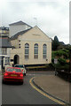
Kingdom Hall, Paignton
The Jehovah's Witnesses place of worship is at the bottom of Colley End Road, which climbs to the left away from the edge of Paignton town centre.
Image: © Derek Harper
Taken: 22 Nov 2007
0.04 miles
3
![Paignton buildings [28]](https://s2.geograph.org.uk/geophotos/06/19/73/6197398_d4b4f8a7_120x120.jpg)
Paignton buildings [28]
Numbers 165 and 167 Winner Street were originally two houses now one shop with accommodation above. Built in the late 18th or early 19th century with a 20th century shopfront. Listed, grade II, with details at: https://historicengland.org.uk/listing/the-list/list-entry/1208568 Winner Street was the principal medieval thoroughfare in Paignton, named after the bishops' vineyard.
Image: © Michael Dibb
Taken: 28 May 2019
0.06 miles
4
![Paignton houses [11]](https://s2.geograph.org.uk/geophotos/06/18/57/6185738_c0259be9_120x120.jpg)
Paignton houses [11]
Numbers 37 and 35 Church Street are mock timber framed.
Image: © Michael Dibb
Taken: 26 May 2019
0.06 miles
5
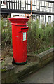
Postbox, Church Street, Paignton
Elizabeth II pillarbox TQ3 111 is near the top of Church Street close to the junction with Winner Street.
Image: © Derek Harper
Taken: 19 Nov 2019
0.07 miles
6
![Paignton houses [23]](https://s3.geograph.org.uk/geophotos/06/19/73/6197315_27b91970_120x120.jpg)
Paignton houses [23]
Number 163 Winner Street is late 18th century and is listed, grade II, with details at: https://historicengland.org.uk/listing/the-list/list-entry/1195222 Winner Street was the principal medieval thoroughfare in Paignton, named after the bishops' vineyard.
Image: © Michael Dibb
Taken: 28 May 2019
0.07 miles
7
![Paignton buildings [10]](https://s0.geograph.org.uk/geophotos/06/18/57/6185736_6bf26adf_120x120.jpg)
Paignton buildings [10]
Somewhat neglected buildings in Church Street, possibly the former Crown & Anchor public house. Under the fourth window is a passageway - Crown & Anchor Way.
Image: © Michael Dibb
Taken: 26 May 2019
0.07 miles
8
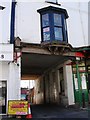
Access through terrace, Crown and Anchor Way
In the past, horses no doubt passed through this passageway. Unbelievably, cars still use it as a route through to Palace Avenue, though it is wholly unsuitable.
Image: © Tom Jolliffe
Taken: 14 Mar 2007
0.07 miles
9
![Paignton houses [22]](https://s2.geograph.org.uk/geophotos/06/19/73/6197314_8726f2b0_120x120.jpg)
Paignton houses [22]
Number 155 Winner Street was originally a shop with accommodation above, now a house. Built circa 1835 and listed, grade II, with details at: https://historicengland.org.uk/listing/the-list/list-entry/1298225 Winner Street was the principal medieval thoroughfare in Paignton, named after the bishops' vineyard.
Image: © Michael Dibb
Taken: 28 May 2019
0.07 miles
10
![Paignton buildings [14]](https://s0.geograph.org.uk/geophotos/06/18/57/6185744_a73301e8_120x120.jpg)
Paignton buildings [14]
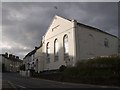
The former Victoria Hotel is now a restaurant. Built in the 1850s and listed, grade II, with details at: https://historicengland.org.uk/listing/the-list/list-entry/1208139
Image: © Michael Dibb
Taken: 26 May 2019
0.08 miles