IMAGES TAKEN NEAR TO
Laura Grove, PAIGNTON, TQ3 2LJ
Introduction
This page details the photographs taken nearby to Laura Grove, TQ3 2LJ by members of the Geograph project.
The Geograph project started in 2005 with the aim of publishing, organising and preserving representative images for every square kilometre of Great Britain, Ireland and the Isle of Man.

There are currently over 7.5m images from over14,400 individuals and you can help contribute to the project by visiting https://www.geograph.org.uk
Image Map
Images are licensed for reuse under creativecommons.org/licenses/by-sa/2.0
Notes
- Clicking on the map will re-center to the selected point.
- The higher the marker number, the further away the image location is from the centre of the postcode.
Image Listing (45 Images Found)
Images are licensed for reuse under creativecommons.org/licenses/by-sa/2.0
Image
Details
Distance
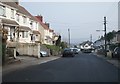
1
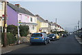
Spot the bus stop
Looking down Maidenway Road.
Image: © Fernweh
Taken: 14 Mar 2014
0.06 miles
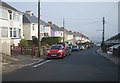
7
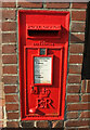
Postbox, Shorton
A close look at Elizabeth II postbox TQ3 33 shown in Image
Image: © Derek Harper
Taken: 2 Jul 2021
0.13 miles
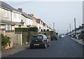
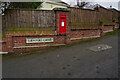
8
Postbox, Shorton
Elizabeth II postbox TQ3 33 is visible in Image Lammas Lane leads uphill from it.
Image: © Derek Harper
Taken: 2 Jul 2021
0.13 miles
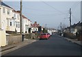
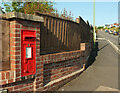
9
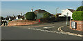
Crossroads, Shorton
A crossroads, with Lammas Lane leading away past Elizabeth II postbox TQ3 33 to the right, and Southfield Avenue the principal road.
Image: © Derek Harper
Taken: 2 Jul 2021
0.13 miles
10
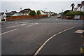
Road junction, Paignton
The junction of Lammas Lane and left to right Southfield Avenue.
Image: © jeff collins
Taken: 31 May 2014
0.14 miles