IMAGES TAKEN NEAR TO
St. Pauls Road, PAIGNTON, TQ3 2DE
Introduction
This page details the photographs taken nearby to St. Pauls Road, TQ3 2DE by members of the Geograph project.
The Geograph project started in 2005 with the aim of publishing, organising and preserving representative images for every square kilometre of Great Britain, Ireland and the Isle of Man.

There are currently over 7.5m images from over14,400 individuals and you can help contribute to the project by visiting https://www.geograph.org.uk
Image Map
Images are licensed for reuse under creativecommons.org/licenses/by-sa/2.0
Notes
- Clicking on the map will re-center to the selected point.
- The higher the marker number, the further away the image location is from the centre of the postcode.
Image Listing (342 Images Found)
Images are licensed for reuse under creativecommons.org/licenses/by-sa/2.0
Image
Details
Distance
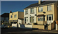
1
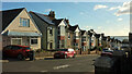
St Paul's Road, Preston
From the top of the road by the track to Cedar Road, with a glimpse of St Paul's Church on the right.
Image: © Derek Harper
Taken: 25 Nov 2021
0.03 miles
2
Cedar Road, Preston
A cul-de-sac, according to the sign on the wall by Torquay Road, but there is a drivable track at the top linking it to St Paul's Road ...
Image: © Derek Harper
Taken: 25 Nov 2021
0.03 miles
3
Cedar Road, Preston
Approaching the top of the road; see also Image
Image: © Derek Harper
Taken: 25 Nov 2021
0.03 miles
4
St Paul's Road, Preston
The top of the road.
Image: © Derek Harper
Taken: 25 Nov 2021
0.04 miles
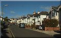
5

Hollicombe Lane
The back lane runs down to meet Torquay Road. On the left is a terrace of six, accounting for half, I think, of all properties on this lane.
Image: © Derek Harper
Taken: 25 Nov 2021
0.04 miles
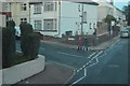
7
Junction on A3022, Preston
St Paul's Road turns off to the right from Torquay Road.
Image: © Derek Harper
Taken: 25 Nov 2021
0.04 miles
8

Top of Cedar Road, Preston
A "cul-de-sac", but with a track leading off to the right to St Paul's Road, another "cul-de-sac".
Image: © Derek Harper
Taken: 25 Nov 2021
0.05 miles
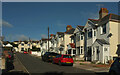
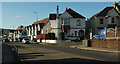
9
Buildings on Torquay Road, Preston
This is the A3022. On the left is an Indian restaurant.
Image: © Derek Harper
Taken: 25 Nov 2021
0.05 miles
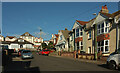
10
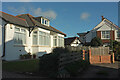
Houses on St Paul's Road, Preston
At the top of the road, from the track linking it to Cedar Road.
Image: © Derek Harper
Taken: 25 Nov 2021
0.05 miles