IMAGES TAKEN NEAR TO
Glen Road, PAIGNTON, TQ3 2AE
Introduction
This page details the photographs taken nearby to Glen Road, TQ3 2AE by members of the Geograph project.
The Geograph project started in 2005 with the aim of publishing, organising and preserving representative images for every square kilometre of Great Britain, Ireland and the Isle of Man.

There are currently over 7.5m images from over14,400 individuals and you can help contribute to the project by visiting https://www.geograph.org.uk
Image Map
Images are licensed for reuse under creativecommons.org/licenses/by-sa/2.0
Notes
- Clicking on the map will re-center to the selected point.
- The higher the marker number, the further away the image location is from the centre of the postcode.
Image Listing (396 Images Found)
Images are licensed for reuse under creativecommons.org/licenses/by-sa/2.0
Image
Details
Distance
1
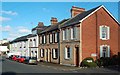
Lower Polsham Road
A late-June evening view, taken at the junction with Glen Road.
Image: © Mary and Angus Hogg
Taken: 28 Jun 2016
0.01 miles
2
![Paignton houses [24]](https://s1.geograph.org.uk/geophotos/06/19/74/6197401_c0ced67a_120x120.jpg)
Paignton houses [24]
Numbers 11A, 15 and 17 Lower Polsham Road are part of a terrace of four houses built in the mid 19th century. Listed, grade II, with details at: https://historicengland.org.uk/listing/the-list/list-entry/1207914
Image: © Michael Dibb
Taken: 29 May 2019
0.01 miles
3
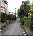
Glen Road, Paignton
From Courtland Road north along Glen Road towards Lower Polsham Road.
Double yellow lines on both sides of Glen Road indicate no parking at any time.
Image: © Jaggery
Taken: 2 Apr 2018
0.03 miles
4
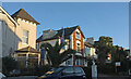
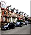
Houses on Polsham Park, Paignton
The ends of two adjacent terraces of four, basking in late sunlight on the east side of the street.
Image: © Derek Harper
Taken: 11 Nov 2021
0.03 miles
5
![Paignton houses [25]](https://s2.geograph.org.uk/geophotos/06/19/85/6198570_fbdd64d9_120x120.jpg)
Paignton houses [25]
Number 8 Lower Polsham Road, Polsham House, was built in the 1850s and the rear block was raised by one storey in the late 19th century. Listed, grade II, with details at: https://historicengland.org.uk/listing/the-list/list-entry/1298231
Image: © Michael Dibb
Taken: 29 May 2019
0.03 miles
6
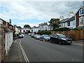
Clamped cars, Polsham Park, Paignton
Possibly for not having the right parking permit.
Image: © Christine Johnstone
Taken: 28 May 2019
0.04 miles
7
![Paignton houses [26]](https://s0.geograph.org.uk/geophotos/06/19/85/6198572_43217be2_120x120.jpg)
Paignton houses [26]
Number 6 Lower Polsham Road was built circa 1850 and is listed for group vale, grade II, with details at: https://historicengland.org.uk/listing/the-list/list-entry/1279521
Image: © Michael Dibb
Taken: 29 May 2019
0.04 miles
8
![Paignton houses [27]](https://s1.geograph.org.uk/geophotos/06/19/85/6198573_0b72ec2f_120x120.jpg)
Paignton houses [27]
Number 4 Lower Polsham Road was built circa 1850. The house has an attractive late 19th or early 20th century enclosed vernadah across front with a lean-to glazed roof and dentil frieze below a bracketed cornice. Listed, along with the garden walls and gate piers, grade II, with details at: https://historicengland.org.uk/listing/the-list/list-entry/1195230
Image: © Michael Dibb
Taken: 29 May 2019
0.04 miles
9
Cars and houses, Courtland Road, Paignton
The north side of Courtland Road viewed looking east towards the Glen Road junction.
Image: © Jaggery
Taken: 2 Apr 2018
0.05 miles
10
![Paignton houses [28]](https://s2.geograph.org.uk/geophotos/06/19/85/6198574_e7ca692f_120x120.jpg)
Paignton houses [28]
Number 2 Lower Polsham Road was built circa 1850 and, along with garden walls and gate piers, is listed, grade II, with details at: https://historicengland.org.uk/listing/the-list/list-entry/1207902
Image: © Michael Dibb
Taken: 29 May 2019
0.05 miles