IMAGES TAKEN NEAR TO
Westerland, Marldon, PAIGNTON, TQ3 1RR
Introduction
This page details the photographs taken nearby to TQ3 1RR by members of the Geograph project.
The Geograph project started in 2005 with the aim of publishing, organising and preserving representative images for every square kilometre of Great Britain, Ireland and the Isle of Man.

There are currently over 7.5m images from over14,400 individuals and you can help contribute to the project by visiting https://www.geograph.org.uk
Image Map
Images are licensed for reuse under creativecommons.org/licenses/by-sa/2.0
Notes
- Clicking on the map will re-center to the selected point.
- The higher the marker number, the further away the image location is from the centre of the postcode.
Image Listing (27 Images Found)
Images are licensed for reuse under creativecommons.org/licenses/by-sa/2.0
Image
Details
Distance
1
Santa at Marldon Christmas Tree Farm
During December motorists coming past Marldon Christmas Tree Farm are greeted by this inflatable Santa Claus.
Image: © Paul Hutchinson
Taken: 1 Dec 2008
0.02 miles
2
Entrance to Marldon Christmas Tree Farm
Between the village of Marldon and the area called Westerland on the Totnes Road lies the entrance to the Christmas Tree Farm.
Image: © Paul Hutchinson
Taken: 1 Dec 2008
0.04 miles
3
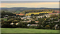
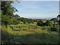
Marldon from Beacon Hill
The car park in the centre is at Marldon Christmas Tree Farm. Taken from Marldon footpath 19.
Image: © Derek Harper
Taken: 31 Aug 2020
0.05 miles
4

Moorview Crescent, Marldon
A recent development at the top of Moorview by the corner with Totnes Road.
Image: © Derek Harper
Taken: 31 Aug 2020
0.08 miles
5
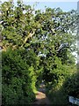
Farm road to Culvertor
A tangle of old oak branches hangs over this lane, which is just to the left of Image Seen from its junction with Farthing Lane.
Image: © Derek Harper
Taken: 17 Jun 2008
0.10 miles
6
Christmas tree farm, Marldon
A western extension of the Marldon Christmas Tree Farm, with the farm road to Culvertor on the left. Seen from Farthing Lane.
Image: © Derek Harper
Taken: 17 Jun 2008
0.12 miles
7

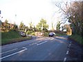
Derestriction sign, Smallwell Lane, Marldon
The derestriction sign needs to be viewed by motorists with some caution. After perhaps twenty more metres, the tarmac starts to disintegrate and this stretch of Smallwell Lane becomes a rough track along a green lane, as shown in Image, so travelling at 50mph might be a mistake.
Image: © Derek Harper
Taken: 16 Jan 2022
0.13 miles
8

Old Milestone by Totnes Road, Marldon parish
Carved stone post by the UC road, in parish of MARLDON (SOUTH HAMS District), 200m West of Marldon Cross, 5m West of Moor View, on grass verge in bank, on North side of road. Erected by the Totnes & Bridgetown-Pomeroy turnpike trust in the 18th century.
Inscription reads:-
4
Miles
from
Totnes
Devon & Dartmoor HER.
HER Number: MDV47855 https://www.heritagegateway.org.uk/Gateway/Results_Single.aspx?uid=MDV47855&resourceID=104
Milestone Society National ID: DV_TNPNa04
Image: © Alan Rosevear
Taken: 4 Jun 2012
0.13 miles
9
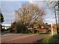
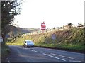
Westerland Cross
The busy road from Berry Pomeroy into Marldon is on the left. The lane on the right drops down the Westerland valley.
Image: © Derek Harper
Taken: 22 Feb 2009
0.13 miles
10

Western Marldon
Looking down Moorview.
Image: © Derek Harper
Taken: 31 Aug 2020
0.14 miles