IMAGES TAKEN NEAR TO
Marldon Cross Hill, PAIGNTON, TQ3 1NF
Introduction
This page details the photographs taken nearby to Marldon Cross Hill, TQ3 1NF by members of the Geograph project.
The Geograph project started in 2005 with the aim of publishing, organising and preserving representative images for every square kilometre of Great Britain, Ireland and the Isle of Man.

There are currently over 7.5m images from over14,400 individuals and you can help contribute to the project by visiting https://www.geograph.org.uk
Image Map
Images are licensed for reuse under creativecommons.org/licenses/by-sa/2.0
Notes
- Clicking on the map will re-center to the selected point.
- The higher the marker number, the further away the image location is from the centre of the postcode.
Image Listing (35 Images Found)
Images are licensed for reuse under creativecommons.org/licenses/by-sa/2.0
Image
Details
Distance
2
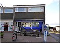
Post Office and Shops,Marldon
At the top end of Marldon Cross Hill.
Image: © jeff collins
Taken: 4 Apr 2014
0.02 miles
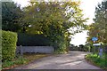
3
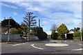
Mini-roundabout in Marldon
Junction of Churscombe Road from the Torbay by-pass with the road to Totnes
Image: © David Smith
Taken: 24 Oct 2015
0.05 miles
4
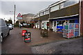
Marldon Cross
Straight ahead for Post Office, shops etc. Left to Totnes and right to Torbay.
Image: © jeff collins
Taken: 4 Apr 2014
0.05 miles
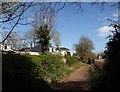
5

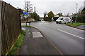
Marldon Cross Hill,Marldon
Looking towards the school at the bottom of the hill.
Image: © jeff collins
Taken: 4 Apr 2014
0.11 miles
6

Old Milestone by Totnes Road, Marldon parish
Carved stone post by the UC road, in parish of MARLDON (SOUTH HAMS District), 200m West of Marldon Cross, 5m West of Moor View, on grass verge in bank, on North side of road. Erected by the Totnes & Bridgetown-Pomeroy turnpike trust in the 18th century.
Inscription reads:-
4
Miles
from
Totnes
Devon & Dartmoor HER.
HER Number: MDV47855 https://www.heritagegateway.org.uk/Gateway/Results_Single.aspx?uid=MDV47855&resourceID=104
Milestone Society National ID: DV_TNPNa04
Image: © Alan Rosevear
Taken: 4 Jun 2012
0.13 miles
7
Leader Lane, Marldon
Starting from Westerland Lane on the edge of Marldon.
Image: © jeff collins
Taken: 31 May 2014
0.13 miles
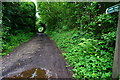
9
Leader Lane, Marldon
A pleasant little track, running between tree-lined banks for the most part, linking Westerland Green with Middle Westerland Cross. The houses on the left are on Churscombe Park.
Image: © Derek Harper
Taken: 5 Apr 2008
0.14 miles
10

Scrubland, Marldon
An area overgrown with brambles and bushes, immediately west of a pair of ponds at the source of the stream down the Occombe valley. The houses are on Vicarage Road.
Image: © Derek Harper
Taken: 29 Oct 2013
0.14 miles