IMAGES TAKEN NEAR TO
Broom Park, TORQUAY, TQ2 8LZ
Introduction
This page details the photographs taken nearby to Broom Park, TQ2 8LZ by members of the Geograph project.
The Geograph project started in 2005 with the aim of publishing, organising and preserving representative images for every square kilometre of Great Britain, Ireland and the Isle of Man.

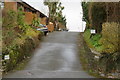
There are currently over 7.5m images from over14,400 individuals and you can help contribute to the project by visiting https://www.geograph.org.uk
Image Map
Images are licensed for reuse under creativecommons.org/licenses/by-sa/2.0
Notes
- Clicking on the map will re-center to the selected point.
- The higher the marker number, the further away the image location is from the centre of the postcode.
Image Listing (151 Images Found)
Images are licensed for reuse under creativecommons.org/licenses/by-sa/2.0
Image
Details
Distance
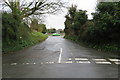
2
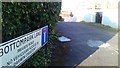
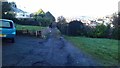
Bottompark Lane, Torquay
Bottompark Lane runs off Barton Hill Rd, Torquay.
Image: © John C
Taken: 7 Mar 2018
0.03 miles
3
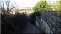
Path westwards of Bottompark Lane
The path runs westward from Bottompark Lane.
Image: © John C
Taken: 7 Mar 2018
0.03 miles
4
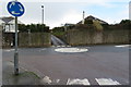
Mini roundabout - Barton Hill Road
The mini roundabout at the junction of Isaacs Road and Barton Hill Road. The small lane ahead is Suncrest Close.
Image: © John C
Taken: 29 Mar 2018
0.04 miles
5
Bottompark Lane, uneven road surface
The lane runs off Barton Hill Road and then turns left to houses, along a rough and uneven road surface.
Image: © John C
Taken: 7 Mar 2018
0.04 miles
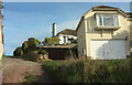
6
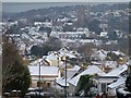
Barton and St Marychurch from Barton Cross
A snowy version of the view that greets you as you round the corner at Barton Cross approaching from Milber. The sunlit houses are on Barton Hill Road and around Erica Drive and Suncrest Park.
Image: © Derek Harper
Taken: 6 Jan 2010
0.05 miles
7
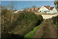
Driveway off Bottom Park Lane
Climbing to meet the lane close to Barton Hill Road, which the houses face.
Image: © Derek Harper
Taken: 19 Feb 2022
0.05 miles
8
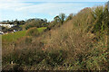
Trees and bushes by Bottom Park Lane
Looking right from Image
Image: © Derek Harper
Taken: 19 Feb 2022
0.05 miles
9
Un-named road - TQ2 8LT
An in-names stretch of road that links Fore Street with Isaacs Road at the junction with Barton Hill Road. Google Maps identifies the road as having postcode TQ2 8LT.
Image: © John C
Taken: 29 Mar 2018
0.05 miles
10
Bottom Park Lane
The track climbs past a side turning to a couple of properties.
Image: © Derek Harper
Taken: 19 Feb 2022
0.05 miles