IMAGES TAKEN NEAR TO
Bellrock Close, TORQUAY, TQ2 8DD
Introduction
This page details the photographs taken nearby to Bellrock Close, TQ2 8DD by members of the Geograph project.
The Geograph project started in 2005 with the aim of publishing, organising and preserving representative images for every square kilometre of Great Britain, Ireland and the Isle of Man.

There are currently over 7.5m images from over14,400 individuals and you can help contribute to the project by visiting https://www.geograph.org.uk
Image Map (Loading...)


Getting Data...Please wait
Leaflet Map data © OpenStreetMap
Images are licensed for reuse under creativecommons.org/licenses/by-sa/2.0
Notes
- Clicking on the map will re-center to the selected point.
- The higher the marker number, the further away the image location is from the centre of the postcode.
Image Listing (132 Images Found)
Images are licensed for reuse under creativecommons.org/licenses/by-sa/2.0
Image
Details
Distance
1
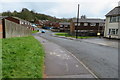
Bellrock Close
Bellrock Close at the East Pafford Avenue end.
Image: © John C
Taken: 29 Mar 2018
0.03 miles
3
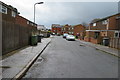
Roberts Close, Watcombe
Roberts Close leads to Cornfield Green.
Image: © John C
Taken: 29 Mar 2018
0.04 miles
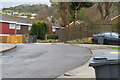
5
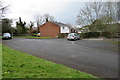
Parking at the end of the road
Used by the residents for parking.
Image: © John C
Taken: 29 Mar 2018
0.04 miles
6
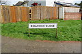
Bellrock Close street name
Taken at the start of Bellrock Close
Image: © John C
Taken: 29 Mar 2018
0.04 miles
9
Style into King George V Playing Field
Off Teignmouth Road and opposite Cornfield Green.
Image: © John C
Taken: 13 May 2018
0.06 miles
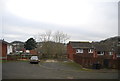
10
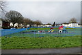
Play area
The play area is between West and East Pafford Avenue.
Image: © John C
Taken: 29 Mar 2018
0.07 miles