IMAGES TAKEN NEAR TO
Furzebrake Close, TORQUAY, TQ2 7FX
Introduction
This page details the photographs taken nearby to Furzebrake Close, TQ2 7FX by members of the Geograph project.
The Geograph project started in 2005 with the aim of publishing, organising and preserving representative images for every square kilometre of Great Britain, Ireland and the Isle of Man.

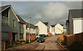
There are currently over 7.5m images from over14,400 individuals and you can help contribute to the project by visiting https://www.geograph.org.uk
Image Map (Loading...)


Getting Data...Please wait
Leaflet Map data © OpenStreetMap
Images are licensed for reuse under creativecommons.org/licenses/by-sa/2.0
Notes
- Clicking on the map will re-center to the selected point.
- The higher the marker number, the further away the image location is from the centre of the postcode.
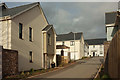
Image Listing (319 Images Found)
Images are licensed for reuse under creativecommons.org/licenses/by-sa/2.0
Image
Details
Distance
1
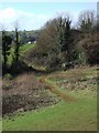
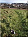
Scott?s Meadow
A "complex planning history" for these fields on the edge of Torquay, next to Riviera Way and the new estates near The Willows. At present, they provide attractive and accessible open space on the urban fringe. Here paths converge on a gap in a field boundary. The buildings in the distance are at the hamlet of Edginswell.
Image: © Derek Harper
Taken: 11 Feb 2007
0.03 miles
2
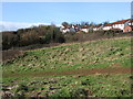
Scott?s Meadow
A reverse view of Image, with Welsury Covert on the skyline.
Image: © Derek Harper
Taken: 11 Feb 2007
0.03 miles
3
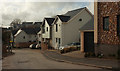
Welsury Road, The Willows
Leading away from Plantation Way.
Image: © Derek Harper
Taken: 17 Feb 2019
0.03 miles
4
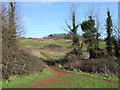
Scott?s Meadow
A path climbs beside a field boundary towards Kingskerswell Road (the row of ivy-clad trees). See Image
Image: © Derek Harper
Taken: 11 Feb 2007
0.04 miles
5
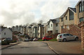
Plantation Way, Primrose Hill, Torquay
From where it is crossed by the path shown in Image
Image: © Derek Harper
Taken: 17 Feb 2019
0.04 miles
6
Plantation Way, Primrose Hill, Torquay
The main road through the new estate; this stretch is seen from the other direction in Image
Image: © Derek Harper
Taken: 17 Feb 2019
0.04 miles
7
Beer can on Scott's Meadow
A solitary piece of litter on what is largely a litter-free open space. Behind, the land drops away to Riviera Way, with the Cadewell estate and the hospital beyond.
Image: © Derek Harper
Taken: 25 Jan 2008
0.04 miles
8

Path, Primrose Hill, Torquay
The path shown in Image] reaches and crosses Tricorn Close.
Image: © Derek Harper
Taken: 17 Feb 2019
0.05 miles
9
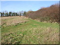
Swallowfield Close and Scott's Meadow
Currently the last outpost of the new developments northwest of Torquay, at least in this direction. The path in the foreground leads up to the mouth of the close.
Image: © Derek Harper
Taken: 11 Feb 2007
0.06 miles
10
Tricorn Close, Primrose Hill, Torquay
Looking right from the road crossing shown in Image] to where the cul-de-sac divides into three.
Image: © Derek Harper
Taken: 17 Feb 2019
0.06 miles