IMAGES TAKEN NEAR TO
Nut Bush Lane, TORQUAY, TQ2 6SD
Introduction
This page details the photographs taken nearby to Nut Bush Lane, TQ2 6SD by members of the Geograph project.
The Geograph project started in 2005 with the aim of publishing, organising and preserving representative images for every square kilometre of Great Britain, Ireland and the Isle of Man.

There are currently over 7.5m images from over14,400 individuals and you can help contribute to the project by visiting https://www.geograph.org.uk
Image Map
Images are licensed for reuse under creativecommons.org/licenses/by-sa/2.0
Notes
- Clicking on the map will re-center to the selected point.
- The higher the marker number, the further away the image location is from the centre of the postcode.
Image Listing (131 Images Found)
Images are licensed for reuse under creativecommons.org/licenses/by-sa/2.0
Image
Details
Distance
1

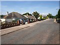
Nut Bush Lane
A little further northwest along Image as it passes one end of Court Road (left) with a seagull swooping.
Image: © Derek Harper
Taken: 12 May 2010
0.05 miles
2
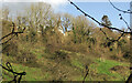
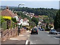
Court Road, Torquay
Most of Torbay's steep interfluves are crowned with modern housing, prominent from all around. In this case the housing is perched above the otherwise fairly rural Cockington valley (behind the buildings on the left).
Image: © Derek Harper
Taken: 29 Jun 2009
0.06 miles
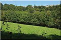
3
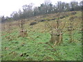
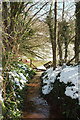
Hillside above Cockington Lane
Looking right from Image], with rows of young trees in tree guards, The houses are on Nut Bush Lane.
Image: © Derek Harper
Taken: 25 Mar 2021
0.09 miles
4
Jubilee Wood - Burial Ground, Cockington
Jubilee Wood is a burial ground for cremated remains. Closed for further interments.
Image: © John C
Taken: 16 Dec 2008
0.10 miles
5
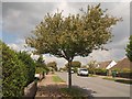
Nut Bush Lane
The ridge-top road in its thoroughly suburban guise; see also Image
Image: © Derek Harper
Taken: 12 May 2010
0.10 miles
6
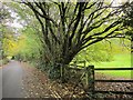
Stream near Cockington
From Cockington Lane. The sheep shown in Image] are on their way into this field.
Image: © Derek Harper
Taken: 20 Mar 2018
0.11 miles
7
Sherwell Rise South, Torquay
A similar view to Image, from Nut Bush Lane. Sherwell Rise North, incidentally, was formerly the name of Image, which climbs beneath the trees on the far side of the valley.
Image: © Derek Harper
Taken: 29 Jun 2009
0.12 miles
8
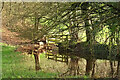
Pool, Cockington valley
See Image; the stream has again created a pond against the field boundary, and reflections to go with it.
Image: © Derek Harper
Taken: 6 Feb 2021
0.12 miles
9
Cockington Lane
The lane up the Cockington valley passes the orchard burial ground shown in Image
Image: © Derek Harper
Taken: 16 Nov 2014
0.13 miles
10
Cockington valley
From further up the same path as Image], with houses on Court Road.
Image: © Derek Harper
Taken: 20 Jul 2020
0.13 miles