IMAGES TAKEN NEAR TO
Rawlyn Road, TORQUAY, TQ2 6PQ
Introduction
This page details the photographs taken nearby to Rawlyn Road, TQ2 6PQ by members of the Geograph project.
The Geograph project started in 2005 with the aim of publishing, organising and preserving representative images for every square kilometre of Great Britain, Ireland and the Isle of Man.

There are currently over 7.5m images from over14,400 individuals and you can help contribute to the project by visiting https://www.geograph.org.uk
Image Map
Images are licensed for reuse under creativecommons.org/licenses/by-sa/2.0
Notes
- Clicking on the map will re-center to the selected point.
- The higher the marker number, the further away the image location is from the centre of the postcode.
Image Listing (232 Images Found)
Images are licensed for reuse under creativecommons.org/licenses/by-sa/2.0
Image
Details
Distance
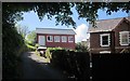
1
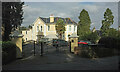
House on Rawlyn Road
White Gables is a typical late Victorian Torquay villa, extended and converted into 12 flats.
Image: © Derek Harper
Taken: 12 Feb 2021
0.00 miles
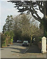
2
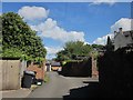
Coach House Lane, Chelston
A back lane that links Vicarage Road and Old Mill Road.
Image: © Derek Harper
Taken: 19 May 2015
0.02 miles
3
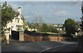
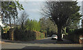
Rawlyn Road, Chelston
Passing Mapeldene as it drops round a bend to meet Old Mill Road.
Image: © Derek Harper
Taken: 12 Feb 2021
0.02 miles
5
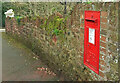
Postbox, Rawlyn Road
George V postbox TQ2 5 is on the wall just beyond Image
Image: © Derek Harper
Taken: 12 Feb 2021
0.04 miles
6
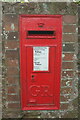
Postbox, Rawlyn Road
George V postbox TQ2 5 is shown in more context at Image
Image: © Derek Harper
Taken: 12 Feb 2021
0.04 miles
7
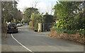
Coach House Lane, Chelston
The traditional sandstone villa on the right is at the corner with Old Mill Road.
Image: © Derek Harper
Taken: 19 May 2015
0.05 miles
8
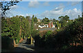
Rawlyn Road, Chelston
The stretch of road seen in the background of Image The houses, many of them divided into flats, are set well back from the road.
Image: © Derek Harper
Taken: 12 Feb 2021
0.05 miles
9
Rawlyn Road, Chelston
The crossroads is shown in Image] from the lane on the right.
Image: © Derek Harper
Taken: 12 Feb 2021
0.05 miles
10
Brooklands Lane, Chelston
Dropping down to St Matthew's Field. The tower of St Matthew's church is on the right.
Image: © Derek Harper
Taken: 25 Feb 2021
0.06 miles