IMAGES TAKEN NEAR TO
Old Mill Road, TORQUAY, TQ2 6PP
Introduction
This page details the photographs taken nearby to Old Mill Road, TQ2 6PP by members of the Geograph project.
The Geograph project started in 2005 with the aim of publishing, organising and preserving representative images for every square kilometre of Great Britain, Ireland and the Isle of Man.

There are currently over 7.5m images from over14,400 individuals and you can help contribute to the project by visiting https://www.geograph.org.uk
Image Map
Images are licensed for reuse under creativecommons.org/licenses/by-sa/2.0
Notes
- Clicking on the map will re-center to the selected point.
- The higher the marker number, the further away the image location is from the centre of the postcode.
Image Listing (358 Images Found)
Images are licensed for reuse under creativecommons.org/licenses/by-sa/2.0
Image
Details
Distance
1
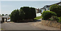
Seaway Close, Torquay
The cul-de-sac is also shown in Image
Image: © Derek Harper
Taken: 6 Jun 2018
0.02 miles
2
Monterey Close, Torquay
The end of the northern arm of the cul-de-sac shown in Image
Image: © Derek Harper
Taken: 12 Feb 2021
0.03 miles
3
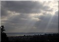
Sunbeams over Chelston
A view from St Michael's Chapel towards Tor Bay, with buildings and trees on the Seaway Lane ridge silhouetted.
Image: © Derek Harper
Taken: 21 Feb 2013
0.03 miles
4
Monterey Close, Torquay
Further along the northern arm of the cul-de-sac shown in Image
Image: © Derek Harper
Taken: 12 Feb 2021
0.03 miles
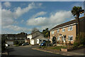
5
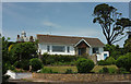
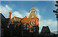
House on Seaway Close, Torquay
Appearing on the left is the tower of the former Manor House Hotel https://www.historicengland.org.uk/listing/the-list/list-entry/1218606 : "a 3-stage tower with a toothed brick cornice below a deep hipped roof with sprocketed eaves, crowned with a lantern with a peaked roof and weathervane ... Eclectic High Victorian style".
Image: © Derek Harper
Taken: 6 Jun 2018
0.03 miles
6
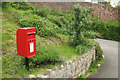
Postbox, Meadow Road, Torquay
Elizabeth II postbox TQ2 367 near the junction of the cul-de-sac with Old Mill Road.
Image: © Derek Harper
Taken: 1 May 2019
0.04 miles
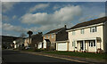
7

Old Mill Road, Chelston
Building work taking place on the steep hill down into the Cockington valley. The lane, steep and narrow though it is, is quite a busy alternative to the seafront.
Image: © Derek Harper
Taken: 19 May 2015
0.04 miles
8
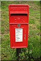
Postbox, Meadow Road, Torquay
A closer view of Elizabeth II postbox TQ2 367 shown in Image], confirming its identity if you look at larger sizes.
Image: © Derek Harper
Taken: 1 May 2019
0.04 miles
9
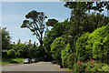
Seaway Lane, Torquay
At the junction with Seaway Close on the left, and, as with Image], showing the roof of the former Manor House Hotel https://www.historicengland.org.uk/listing/the-list/list-entry/1218606 .
Image: © Derek Harper
Taken: 6 Jun 2018
0.05 miles
10
Manor House Apartments, Chelston
Formerly the Manor House Hotel and originally Chelston Cross "Circa 1867 rather eccentric, red limestone and sandstone, large house of 2 1/2 storeys. Asymmetrical parts with gabled dormers and gothicised fenestration. Entrance front splayed with central gabled tower porch with lancet windows to side and oriel to front on 1st floor. Tower to right with belvedere surmounted by slate spire" https://www.heritagegateway.org.uk/Gateway/Results_Single.aspx?uid=MDV47863&resourceID=104 . "The house was the residence from 1867 of William Froude friend of i. K. Brunel. It was here that he developed and built, on a site marked by {a} plaque in seaway lane, the first experimental ship tank in the world" Image Other photos are at https://www.geograph.org.uk/search.php?i=161058724 .
Image: © Derek Harper
Taken: 8 Jul 2022
0.05 miles