IMAGES TAKEN NEAR TO
Burridge Road, TORQUAY, TQ2 6NA
Introduction
This page details the photographs taken nearby to Burridge Road, TQ2 6NA by members of the Geograph project.
The Geograph project started in 2005 with the aim of publishing, organising and preserving representative images for every square kilometre of Great Britain, Ireland and the Isle of Man.

There are currently over 7.5m images from over14,400 individuals and you can help contribute to the project by visiting https://www.geograph.org.uk
Image Map
Images are licensed for reuse under creativecommons.org/licenses/by-sa/2.0
Notes
- Clicking on the map will re-center to the selected point.
- The higher the marker number, the further away the image location is from the centre of the postcode.
Image Listing (107 Images Found)
Images are licensed for reuse under creativecommons.org/licenses/by-sa/2.0
Image
Details
Distance
1
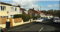
The Reeves Road, Chelston
Seen from close to the top of the road, the junction with Burridge Road.
Image: © Derek Harper
Taken: 25 Feb 2021
0.02 miles
2

Junction on Burridge Road, Chelston
With The Reeves Road. At the top of the hill beyond, Burridge Road reaches a T junction with Sherwell Rise South.
Image: © Derek Harper
Taken: 25 Feb 2021
0.03 miles
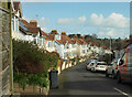
3

Burridge Road, Chelston
The road dips to a junction with The Reeves Road on the right and then climbs to meet Sherwell Rise South.
Image: © Derek Harper
Taken: 25 Feb 2021
0.03 miles
4
Leys Road, Chelston
From the junction with Burridge Road, shown in Image
Image: © Derek Harper
Taken: 25 Feb 2021
0.04 miles
5
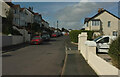
Burridge Road, Chelston
The right turn is Leys Road.
Image: © Derek Harper
Taken: 25 Feb 2021
0.06 miles
6
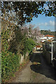
Back lane, Chelston
From Burridge Road.
Image: © Derek Harper
Taken: 25 Feb 2021
0.06 miles
7
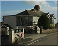
Bike and house, Burridge Road
By the back lane shown in Image
Image: © Derek Harper
Taken: 25 Feb 2021
0.06 miles
8
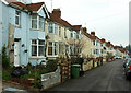
Leys Road, Chelston
Short terraces, mostly of four properties, characterise Leys Road.
Image: © Derek Harper
Taken: 4 Mar 2021
0.06 miles
9
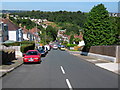
Sherwell Rise South in Chelston
Looking down the hill from the top of Sherwell Rise South the building with the green roof, in the bottom of the valley, is St Peters Church on Queensway..
Image: © Paul Anderson
Taken: 4 Aug 2007
0.07 miles
10
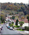
Higher Chelston, Torquay
1930's housing development, Sherwell Rise South, on what was then the outer limit of Torquay
Image: © Crispin Purdye
Taken: 18 Nov 2005
0.08 miles