IMAGES TAKEN NEAR TO
Nut Bush Lane, TORQUAY, TQ2 6LF
Introduction
This page details the photographs taken nearby to Nut Bush Lane, TQ2 6LF by members of the Geograph project.
The Geograph project started in 2005 with the aim of publishing, organising and preserving representative images for every square kilometre of Great Britain, Ireland and the Isle of Man.

There are currently over 7.5m images from over14,400 individuals and you can help contribute to the project by visiting https://www.geograph.org.uk
Image Map
Images are licensed for reuse under creativecommons.org/licenses/by-sa/2.0
Notes
- Clicking on the map will re-center to the selected point.
- The higher the marker number, the further away the image location is from the centre of the postcode.
Image Listing (124 Images Found)
Images are licensed for reuse under creativecommons.org/licenses/by-sa/2.0
Image
Details
Distance
1
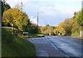
Nut Bush Corner
The city limits on the Marldon Road where Nut Bush Lane turns off to the left, although there is a small estate behind a bank on the right as the road dips.
Image: © Derek Harper
Taken: 30 Oct 2010
0.02 miles
2
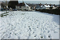
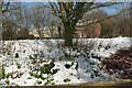
Snow at Avon Road, Shiphay
An expanse of snow-covered grass beside Marldon Road.
Image: © Derek Harper
Taken: 20 Mar 2018
0.03 miles
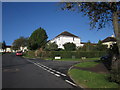
3
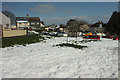
Snow at Avon Road, Shiphay
Looking left from where Image] was taken, with cars parked in a small crescent opposite the junction with Torridge Avenue.
Image: © Derek Harper
Taken: 20 Mar 2018
0.03 miles
4
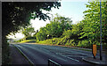
Marldon Road
Seen at Nut Bush Corner, from beside a pedestrian refuge sited where the John Musgrave Heritage Trail emerges from a housing estate and crosses to reach the Cockington valley.
Image: © Derek Harper
Taken: 5 Jun 2021
0.04 miles
5
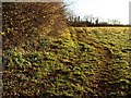
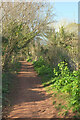
Field by Nut Bush Lane
Seen from beside Image, looking up the side of a sloping field. Image runs behind the trees at the top.
Image: © Derek Harper
Taken: 11 Dec 2008
0.04 miles
6
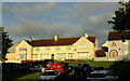
Houses on Avon Road, Shiphay
Above a small crescent.
Image: © Derek Harper
Taken: 5 Jun 2021
0.04 miles
7
Junction on Torridge Avenue
The side road is Severn Close; the estate's roads are all named after Devon rivers. Up at the top is a T-junction with Avon Road.
Image: © Derek Harper
Taken: 4 Oct 2012
0.04 miles
8
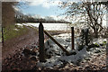
Snow near Nut Bush Corner
Looking left from just past the gate shown in Image
Image: © Derek Harper
Taken: 20 Mar 2018
0.05 miles
9
John Musgrave Heritage Trail approaching Marldon Road
A little further along from Image
Image: © Derek Harper
Taken: 25 Mar 2021
0.06 miles
10
Bank and houses, Nut Bush Corner
Looking left from where Image] was taken. The houses across Marldon Road are on Fernworthy Close.
Image: © Derek Harper
Taken: 20 Mar 2018
0.06 miles