IMAGES TAKEN NEAR TO
Heywood Close, TORQUAY, TQ2 6DJ
Introduction
This page details the photographs taken nearby to Heywood Close, TQ2 6DJ by members of the Geograph project.
The Geograph project started in 2005 with the aim of publishing, organising and preserving representative images for every square kilometre of Great Britain, Ireland and the Isle of Man.

There are currently over 7.5m images from over14,400 individuals and you can help contribute to the project by visiting https://www.geograph.org.uk
Image Map
Images are licensed for reuse under creativecommons.org/licenses/by-sa/2.0
Notes
- Clicking on the map will re-center to the selected point.
- The higher the marker number, the further away the image location is from the centre of the postcode.
Image Listing (545 Images Found)
Images are licensed for reuse under creativecommons.org/licenses/by-sa/2.0
Image
Details
Distance
1
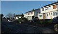
Heywood Close, Torquay
Named after Thomas Heywood, the C15/C16 playwright, though I'm not sure why playwrights of that era should feature so heavily in this suburb of Torquay. One of our cats took up residence here, halfway between our old house and our new house, and we eventually gave up retrieving him. The attraction must have been the better food rather than the pedigree queens, unless one queries the efficacy of the vet who had charged us for "seeing to" him.
Image: © Derek Harper
Taken: 7 Feb 2016
0.01 miles
2
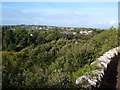
View from St Michael's Chapel, Torquay
This view looks WNW, further to the right than Image, with housing on Queensway beyond the wooded valley containing the A380 and the railway. Beyond is the suburb of Shiphay, with the South Devon countryside as a backdrop. You'll need a magnifying glass, but the tiny white dot on the horizon in the centre is Image which is how I discovered Geograph.
Image: © Derek Harper
Taken: 8 Oct 2006
0.02 miles
3
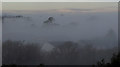
Trees in the mist, Shiphay
A view from St Michael's Chapel across northern Chelston and Shiphay.
Image: © Derek Harper
Taken: 6 Mar 2018
0.02 miles
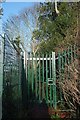
4
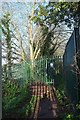
Second gate on path from Queensway
Taken from the gate shown in Image], which I could probably have opened; but there's little point as this second gate is clearly padlocked and bears a notice, albeit an ambiguous one: "Private property: there is no intention to dedicate this land as a right of way". That's more or less what it says on the coast path where it crosses Torquay harbour.
Image: © Derek Harper
Taken: 7 Feb 2016
0.04 miles
5
Gate across path, Queensway
I used to walk this path regularly; it runs between the primary school on Queensway and the girls' grammar, and formed part of a route from my house to Cockington that involved very little in the way of roads. But alas, not for the last few years, since it was blocked off. The only photographic record I have seems to be Image
Image: © Derek Harper
Taken: 7 Feb 2016
0.04 miles
6
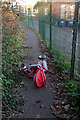
Trike by Queenway, Torquay
Oops! Scene of a toddler cycling mishap or an abandoned / dumped vehicle - possibly both. This is on the path leading from the gate seen in Image
Image: © Derek Harper
Taken: 7 Jan 2021
0.04 miles
7
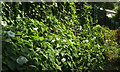
Bindweed near Queensway Primary School
Calystegia sepium by a fence at the rear of the school.
Image: © Derek Harper
Taken: 8 Jul 2019
0.04 miles
8
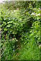
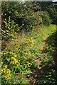
Overgrown path from Queensway
A similar problem to Image I did clear a way through with secateurs in about February this year, but I get the impression I'm the only person who uses this rather useful path. And on this occasion I had failed to bring that crucial piece of equipment, although a machete would be far more help. Perhaps there will be a reasonable crop of blackberries in a couple of months. The guelder rose on the right is less of an issue.
Image: © Derek Harper
Taken: 2 Jun 2021
0.05 miles
9
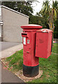
Postbox, Queensway
Elizabeth II postbox TQ2 402 is just south of the row of shops (left) at the highest point along Queensway.
Image: © Derek Harper
Taken: 10 Sep 2018
0.05 miles
10
Path, Shiphay
The path shown in Image] works its way around the rear of the primary school towards Queensway.
Image: © Derek Harper
Taken: 25 Jul 2017
0.06 miles