IMAGES TAKEN NEAR TO
Sherwell Lane, TORQUAY, TQ2 6BE
Introduction
This page details the photographs taken nearby to Sherwell Lane, TQ2 6BE by members of the Geograph project.
The Geograph project started in 2005 with the aim of publishing, organising and preserving representative images for every square kilometre of Great Britain, Ireland and the Isle of Man.

There are currently over 7.5m images from over14,400 individuals and you can help contribute to the project by visiting https://www.geograph.org.uk
Image Map (Loading...)


Getting Data...Please wait
Leaflet Map data © OpenStreetMap
Images are licensed for reuse under creativecommons.org/licenses/by-sa/2.0
Notes
- Clicking on the map will re-center to the selected point.
- The higher the marker number, the further away the image location is from the centre of the postcode.
Image Listing (287 Images Found)
Images are licensed for reuse under creativecommons.org/licenses/by-sa/2.0
Image
Details
Distance
1
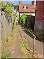
Alley, Chelston
Footpath TQ/85 drops, with the aid of railings, to meet Sherwell Lane. The house also appears in Image
Image: © Derek Harper
Taken: 18 Jun 2014
0.01 miles
2
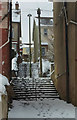
Steps from Rocket Park, Torquay
Footpath TQ 84 climbs to Sherwell Lane; the steps beyond are on footpath TQ 85, which climbs on to Sherwell Park Road.
Image: © Derek Harper
Taken: 19 Mar 2018
0.02 miles
3
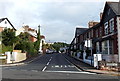
Sherwell Lane, Torquay
Looking NW across Sherwell Hill.
Image: © Jaggery
Taken: 5 Jul 2014
0.02 miles
4
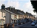
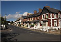
Sherwell Lane, Torquay
Taken from Sherwell Valley Road, which becomes Sherwell Lane at the junction with Mallock Road. Beyond this is a terrace of 13 properties.
Image: © Derek Harper
Taken: 9 Jan 2010
0.02 miles
5
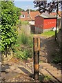
Post and steps, Chelston
Further down footpath TQ/85 from Image], with the path approaching a back lane behind houses on Sherwell Lane.
Image: © Derek Harper
Taken: 18 Jun 2014
0.02 miles
6
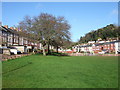
Rocket Park, Torquay
Formerly known as Mallock Park (Mallock Road is on the right), this is just across Sherwell Hill from Image, and more the sort of place you can actually play in. The playground has recently been refurbished. On the left are the backs of houses on Sherwell Lane. The steep wooded hill is in the grounds of Rowcroft Hospice.
Image: © Derek Harper
Taken: 3 Mar 2007
0.04 miles
7
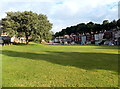
Rocket Park, Torquay
Another view across Image, with the terraces of Mallock Road behind.
Image: © Derek Harper
Taken: 9 Jan 2010
0.04 miles
8
NW corner of Sherwell Park, Chelston, Torquay
Viewed from Sherwell Hill. Sherwell Park is also known locally as Pretty Park.
Image: © Jaggery
Taken: 5 Jul 2014
0.04 miles
9
Sherwell Lane, Torquay
The junction, a crossroads with Sherwell Hill, is shown from a different angle in Image The houses are built of a distinctive red sandstone.
Image: © Derek Harper
Taken: 24 Sep 2012
0.05 miles
10
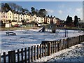
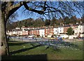
Playground, Rocket Park, Torquay
The playground in the snow, seen from the track along the southern side of the park. Beyond is the rear of a terrace on Mallock Road.
Image: © Derek Harper
Taken: 9 Jan 2010
0.05 miles