IMAGES TAKEN NEAR TO
Blindwylle Road, TORQUAY, TQ2 6AE
Introduction
This page details the photographs taken nearby to Blindwylle Road, TQ2 6AE by members of the Geograph project.
The Geograph project started in 2005 with the aim of publishing, organising and preserving representative images for every square kilometre of Great Britain, Ireland and the Isle of Man.

There are currently over 7.5m images from over14,400 individuals and you can help contribute to the project by visiting https://www.geograph.org.uk
Image Map
Images are licensed for reuse under creativecommons.org/licenses/by-sa/2.0
Notes
- Clicking on the map will re-center to the selected point.
- The higher the marker number, the further away the image location is from the centre of the postcode.
Image Listing (313 Images Found)
Images are licensed for reuse under creativecommons.org/licenses/by-sa/2.0
Image
Details
Distance
1
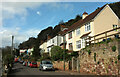
Blindwylle Road, Chelston
A cul-de-sac on the side of the Sherwell valley.
Image: © Derek Harper
Taken: 25 Feb 2021
0.01 miles
2
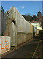
Path, Chelston
An interesting fence on top of a door in an arch. The path links Mallock Road to Blindwylle Road.
Image: © Derek Harper
Taken: 25 Feb 2021
0.03 miles
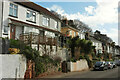
3
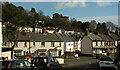
Houses, Chelston
From The Reeves Road, looking across Sherwell Valley Road, which becomes Sherwell Lane as it passes the junction with Mallock Road. The white house in the centre is a recent addition to the terrace on Mallock Road.
Image: © Derek Harper
Taken: 25 Feb 2021
0.04 miles
4
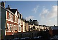
Rear of terraces, Mallock Road, Chelston
The terraces back onto Image and can be seen on the right of that image. This is taken from the other, west, end of the park.
Image: © Derek Harper
Taken: 9 Jan 2010
0.05 miles
5
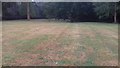
SE end of the meadow at Rowcroft
Rain is needed to restore the grassland.
Image: © John C
Taken: 4 Jul 2018
0.05 miles
6
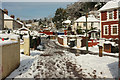
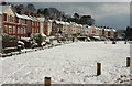
Exit from Rocket Park, Torquay, in the snow
The northwest corner of the park seen from the same place as Image], with the track along the edge of the park meeting Mallock Road.
Image: © Derek Harper
Taken: 19 Mar 2018
0.05 miles
7
Junction, Chelston
Mallock Road to the left, Blindwylle Road (a cul-de-sac) to the right.
Image: © Derek Harper
Taken: 25 Feb 2021
0.05 miles
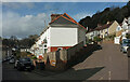
8
Houses on Blindwylle Road, Chelston
Set well above the road, reflecting the fact that the cul-de-sac is laid out along a hillside.
Image: © Derek Harper
Taken: 25 Feb 2021
0.05 miles
9
Rocket Park in the snow
From close to the northwest corner of the park, with the rears of houses on Mallock Road.
Image: © Derek Harper
Taken: 19 Mar 2018
0.06 miles
10

Rowcroft Estate road sign
Approaching Rowcroft Hospice on their private road.
Image: © John C
Taken: 6 Apr 2018
0.06 miles