IMAGES TAKEN NEAR TO
Tor Church Road, TORQUAY, TQ2 5UR
Introduction
This page details the photographs taken nearby to Tor Church Road, TQ2 5UR by members of the Geograph project.
The Geograph project started in 2005 with the aim of publishing, organising and preserving representative images for every square kilometre of Great Britain, Ireland and the Isle of Man.

There are currently over 7.5m images from over14,400 individuals and you can help contribute to the project by visiting https://www.geograph.org.uk
Image Map (Loading...)


Getting Data...Please wait
Leaflet Map data © OpenStreetMap
Images are licensed for reuse under creativecommons.org/licenses/by-sa/2.0
Notes
- Clicking on the map will re-center to the selected point.
- The higher the marker number, the further away the image location is from the centre of the postcode.
Image Listing (958 Images Found)
Images are licensed for reuse under creativecommons.org/licenses/by-sa/2.0
Image
Details
Distance
1
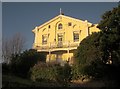
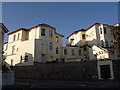
Villa, Torquay
"Sited high above Tor Church Road" is this attractive mid-C19 villa http://list.english-heritage.org.uk/resultsingle.aspx?uid=1206857&searchtype=mapsearch . The verandah is later in date.
Image: © Derek Harper
Taken: 6 Jan 2015
0.01 miles
2
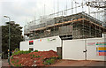
Buildings under construction, Torquay
"Stunning 3 and 4 bedroom houses" named "Tor Manor" are being built on the site of a former conservative club and then a car park. The trees on the left are across St Efride's Road in St Andrew's churchyard,
Image: © Derek Harper
Taken: 12 Apr 2019
0.02 miles
3
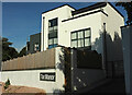
Tor Manor, Torquay
The building shown under construction at Image has been completed. This is on Tor Church Road.
Image: © Derek Harper
Taken: 6 Oct 2022
0.02 miles
4
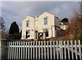
Derelict building, Tor Church Road, Torquay
This used to be Tor Central Social Club, which closed in 2002. Standing in a prominent position close to the town centre, it has been derelict for many years. Just two walls now remain of the building which dates from the mid-C19. http://findarticles.com/p/news-articles/western-morning-news-the/mi_8027/is_20090512/restore-fortunes-forlorn-social-club/ai_n44181590/
Image: © Derek Harper
Taken: 16 Feb 2010
0.02 miles
5
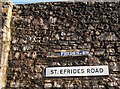
Road name, St Efride's Road, Torquay
The old blue sign has been damaged and now reads simply "FRIDES.RD." Who was St Efride? So far, I've been unable to find any information.
Image: © Derek Harper
Taken: 11 Feb 2014
0.02 miles
6
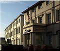
Hotels on Tor Church Road, Torquay
The hotels shown in Image from the other direction.
Image: © Derek Harper
Taken: 4 May 2009
0.02 miles
7
Seascape Hotel, Torquay
Viewed across Tor Church Road.
Image: © Jaggery
Taken: 5 Jul 2014
0.02 miles
8
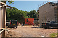
Building site, St Efride's Road, Torquay
Once the site of a Conservative club, then a car park for some years, and now being developed as Tor Manor, a number of residential units - about 8, I think. Its address is on Tor Church Road.
Image: © Derek Harper
Taken: 20 May 2019
0.02 miles
9
Seascape Hotel, Torquay
The buildings catching the evening sun, as seen from the junction of Scarborough Road and Croft Road; the hotel actually fronts Tor Church Road.
Image: © Derek Harper
Taken: 26 Aug 2007
0.03 miles
10
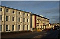
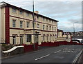
Hotels on Tor Church Road, Torquay
This is nearer the town centre than Image, and the back street is now a principal road linking Castle Circus to the Torre Abbey valley. On the left is the Majestic Templestowe, and ahead is the Seascape, both glowing in early morning sunshine.
Image: © Derek Harper
Taken: 4 May 2009
0.03 miles