IMAGES TAKEN NEAR TO
Warren Road, TORQUAY, TQ2 5ST
Introduction
This page details the photographs taken nearby to Warren Road, TQ2 5ST by members of the Geograph project.
The Geograph project started in 2005 with the aim of publishing, organising and preserving representative images for every square kilometre of Great Britain, Ireland and the Isle of Man.

There are currently over 7.5m images from over14,400 individuals and you can help contribute to the project by visiting https://www.geograph.org.uk
Image Map (Loading...)


Getting Data...Please wait
Leaflet Map data © OpenStreetMap
Images are licensed for reuse under creativecommons.org/licenses/by-sa/2.0
Notes
- Clicking on the map will re-center to the selected point.
- The higher the marker number, the further away the image location is from the centre of the postcode.
Image Listing (1335 Images Found)
Images are licensed for reuse under creativecommons.org/licenses/by-sa/2.0
Image
Details
Distance
1
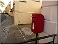
Torquay: postbox № TQ2 3, Warren Road
This little postbox is emptied finally at 6pm on weekdays and at 12:30pm on Saturdays.
Image: © Chris Downer
Taken: 28 Aug 2009
0.02 miles

3

Torre Abbey Sands
View of Torquay from the beach close to the Torre Abbey. This shows how hilly the area surrounding Torquay is. The choice of this area to be the centre of the town was the presence of a suitable inlet which allowed fishing vessels to berth next to the shore. This harbour is located just behind the Torquay Wheel, refer to picture Image, in the centre of the photograph. For a view from the opposite direction refer to picture Image
Image: © Len Williams
Taken: 11 May 2014
0.02 miles
4
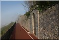
Rock Walk, Torquay
With a limestone wall running beside it, the resurfaced footpath heads into the mist.
Image: © Derek Harper
Taken: 30 Sep 2011
0.03 miles
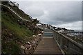
7
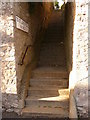
Torquay: steps to St. Luke?s Road, North and South
Steps leading from Warren Road to both St. Luke's Road North and St. Luke's Road South, as explained by the sign.
Image: © Chris Downer
Taken: 28 Aug 2009
0.04 miles
8
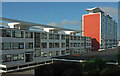
Flats on Waldon Hill
Waldon Court and Lytton House are on the south side of St Luke's Road South.
Image: © Derek Harper
Taken: 14 Oct 2021
0.04 miles
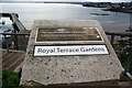
9
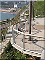
Walkway, Royal Terrace Gardens, Torquay
Image: © Derek Harper
Taken: 15 Mar 2011
0.04 miles
10
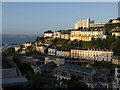
Torquay: Warren Road and Rock Road
A view in morning sunlight from Braddons Hill Road East. The topmost block of flats is Kingsdale Court. Warren Road is the next street down, with Rock Road below, and Fleet Street in shadow.
Image: © Derek Harper
Taken: 28 Aug 2009
0.04 miles