IMAGES TAKEN NEAR TO
Factory Row, TORQUAY, TQ2 5QQ
Introduction
This page details the photographs taken nearby to Factory Row, TQ2 5QQ by members of the Geograph project.
The Geograph project started in 2005 with the aim of publishing, organising and preserving representative images for every square kilometre of Great Britain, Ireland and the Isle of Man.

There are currently over 7.5m images from over14,400 individuals and you can help contribute to the project by visiting https://www.geograph.org.uk
Image Map
Images are licensed for reuse under creativecommons.org/licenses/by-sa/2.0
Notes
- Clicking on the map will re-center to the selected point.
- The higher the marker number, the further away the image location is from the centre of the postcode.
Image Listing (796 Images Found)
Images are licensed for reuse under creativecommons.org/licenses/by-sa/2.0
Image
Details
Distance
2
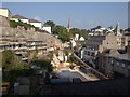
Building site, Factory Row
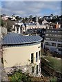
The vacant site shown in Image two years on, with some progress being made in development. Beyond are buildings near Castle Circus, including Upton church and the town hall.
Image: © Derek Harper
Taken: 27 Sep 2008
0.01 miles
3
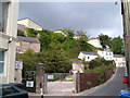
Factory Row from Temperance Street, Torquay
This vacant site is in the heart of Torquay just yards from Castle Circus. There was once a church on the angle between the roads, in use as a second-hand store in the 1970s.
Image: © Derek Harper
Taken: 26 Aug 2006
0.01 miles
4
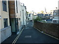
Factory Row, Torquay
The building on the right can be seen in Image; this view looks along the street past the junction with Temperance Street to the new hostel shown in Image
Image: © Derek Harper
Taken: 3 Dec 2009
0.01 miles
5
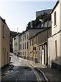
Looking closely at the scrapes
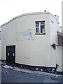
The building at the junction of Temperance Street and Factory Row forces high vehicles to negotiate a rather tight bend. Evidence of a number of strikes are clearly common.
Image: © Neil Owen
Taken: 16 Sep 2022
0.02 miles
6
New hostel for the homeless, Factory Row, Torquay
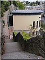
These steps, part of a handy pedestrian route from Abbey Road to Castle Circus, were closed for some years while the former centre for the homeless was demolished; it has now been replaced with this new building and the route reopened.
"The new hostel for homeless and vulnerable single people is to be named after its founder Leonard Stocks, who set up the Torbay Churches Homeless Trust at Factory Row in 1990.
"It will help around 50 people a year as each person will have a six-month tenancy.
"It will have 24 bedrooms with en-suite facilities as well as training rooms, staff offices, GP consulting room, treatment room, and a roof terrace." http://www.thisisplymouth.co.uk/news/Shekinah-Chapter-new-hostel/article-1072224-detail/article.html
Image: © Derek Harper
Taken: 3 Oct 2009
0.02 miles
7
Leonard Stocks Centre, Torquay
Another view of Image, with the town hall at Castle Circus in the background.
Image: © Derek Harper
Taken: 27 Mar 2010
0.02 miles
8
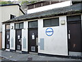
Public conveniences on Factory Row
A small block just off the main road, with surveillance.
Image: © Neil Owen
Taken: 16 Sep 2022
0.02 miles
9
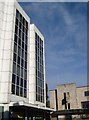
Tor Hill House and Electric House, Castle Circus,Torquay
The five-storey office block on the left, Tor Hill House dates from the 1960s. One of the 26,791 branches of Subway is the latest tenant on the ground floor facing Castle Circus. Electric House, on the other side of Union Street, is a progressive building of 1935, which became part of the council's offices in 1985, and adjoins the Town Hall.
Image: © Derek Harper
Taken: 25 Nov 2006
0.03 miles
10
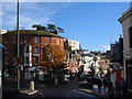
Castle Circus, Torquay
With Union Street heading off downhill in the direction of the harbour. A bus is just arriving to the left of the camera, and the Christmas decorations are up. The white building on the hill behind is "The Castle", a mid-C19 villa.
Image: © Derek Harper
Taken: 25 Nov 2006
0.03 miles