IMAGES TAKEN NEAR TO
Union Street, TORQUAY, TQ2 5QP
Introduction
This page details the photographs taken nearby to Union Street, TQ2 5QP by members of the Geograph project.
The Geograph project started in 2005 with the aim of publishing, organising and preserving representative images for every square kilometre of Great Britain, Ireland and the Isle of Man.

There are currently over 7.5m images from over14,400 individuals and you can help contribute to the project by visiting https://www.geograph.org.uk
Image Map
Images are licensed for reuse under creativecommons.org/licenses/by-sa/2.0
Notes
- Clicking on the map will re-center to the selected point.
- The higher the marker number, the further away the image location is from the centre of the postcode.
Image Listing (869 Images Found)
Images are licensed for reuse under creativecommons.org/licenses/by-sa/2.0
Image
Details
Distance
1
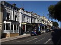
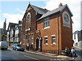
Union Street, Torquay
This steep stretch is above Castle Circus, as the street climbs towards the level section through Torre. These shops are opposite Image
Image: © Derek Harper
Taken: 8 May 2009
0.01 miles
2
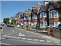
Morgan Avenue Torquay
This residential avenue is located very close to Torquay town centre.
For future reference the 6 bedroom mid terraced house on the right was on the market for £249,950 in July 2007
Image: © Paul Anderson
Taken: 5 Aug 2007
0.01 miles
3
Jolly Judge, Torquay
A traditional English pub in Union Street.
Image: © Jaggery
Taken: 5 Jul 2014
0.01 miles
4
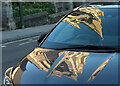
Spire on car, Torquay
A reflection of the spire of St Mary Magdalene church, as shown in Image], reflected on a clean and shiny car parked on Union Street.
Image: © Derek Harper
Taken: 18 Nov 2022
0.01 miles
6
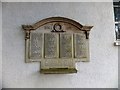
War memorial near St Mary Magdalene, Torquay
This memorial is on the wall of the hall by the church. It refers to "This school" but does not name it. It was Upton National School and was originally where the Magistrates Court stands today Image In fact when the school was demolished the court building was built on the old foundations. The war memorial was later relocated to the external wall of the parish hall in 1956. The names are all in alphabetical order except for the addition of Alford, C at the end of the first column, Bowden, CJ, Blackler, J, and Palmer, P. As Alford and Palmer were clearly afterthoughts, I wonder why their names have not been repainted. And was Blackler's name added, and then removed? It has not been repainted, although Bowden's has. My thanks to fellow Geograph-er JohnC who added the information about the school and the court building.
Image: © David Smith
Taken: 19 Feb 2013
0.02 miles
7
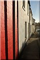
Higher Union Lane, Torquay
Buildings on the northeast side of the one-way street.
Image: © Derek Harper
Taken: 21 Nov 2015
0.02 miles
8
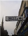
MOT sign, Torquay
In need of a lick of paint, this rather modest advert on the corner of a locksmith's directs motorists along Higher Union Lane. On the left is Image
Image: © Derek Harper
Taken: 27 Feb 2013
0.02 miles
9
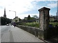
Park, Union Street, Torquay
The view down Union Street, with the park on the right and St Mary Magdalen in the distance on the left.
Image: © Tom Jolliffe
Taken: 3 May 2010
0.02 miles
10
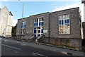
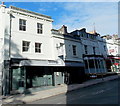
Torquay Magistrates' Court
Entrance viewed across Union Street. Castle Chambers http://www.geograph.org.uk/photo/4064148 are on the left.
Image: © Jaggery
Taken: 5 Jul 2014
0.02 miles