IMAGES TAKEN NEAR TO
St. Lukes Road, TORQUAY, TQ2 5NY
Introduction
This page details the photographs taken nearby to St. Lukes Road, TQ2 5NY by members of the Geograph project.
The Geograph project started in 2005 with the aim of publishing, organising and preserving representative images for every square kilometre of Great Britain, Ireland and the Isle of Man.

There are currently over 7.5m images from over14,400 individuals and you can help contribute to the project by visiting https://www.geograph.org.uk
Image Map
Images are licensed for reuse under creativecommons.org/licenses/by-sa/2.0
Notes
- Clicking on the map will re-center to the selected point.
- The higher the marker number, the further away the image location is from the centre of the postcode.
Image Listing (817 Images Found)
Images are licensed for reuse under creativecommons.org/licenses/by-sa/2.0
Image
Details
Distance
1
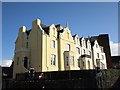
Terrace, St Luke's Road, Torquay
This terrace on the corner of Abbey Road, with its distinctively-shaped gables, was formerly in a sad state, but has now been smartly restored.
Image: © Derek Harper
Taken: 21 Mar 2008
0.01 miles
2
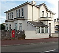
Large postbox in a wall, St Luke's Road, Torquay
Noticeably bigger than a standard wall-mounted box, located at the edge of Waverley House Mental Health Centre. There are many hotels and guest houses hereabouts - perhaps this size of box is needed to accommodate the volume of tourist postcards...
Image: © Jaggery
Taken: 6 Jul 2014
0.01 miles
3
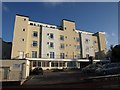
Wallis Court, Torquay
A residential and nursing home at Matlock Terrace at the junction of Shedden Hill Road and St Luke's Road.
Image: © Derek Harper
Taken: 9 Jan 2010
0.01 miles
4
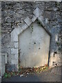
An empty niche
This roadside feature between St Luke's Road and Abbey Road appears to have lost its essence. Was this a water fountain (with a small pipe still extruding), a milestone or a marker of some sort? Old maps show nothing of note here.
Image: © Neil Owen
Taken: 16 Sep 2022
0.02 miles
5
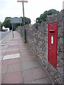
Torquay: postbox № TQ2 9, St. Luke?s Road
This Elizabeth II-reign postbox is a large one – I had just watched someone post some A4 sized items with no difficulty – and is emptied finally at 5:30pm on weekdays and at 12:30pm on Saturdays.
Image: © Chris Downer
Taken: 27 Aug 2009
0.02 miles
6
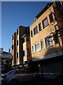
Commerce House, Abbey Road
A brick block of offices beside the junction with Burridge Lane and St Luke's Road.
Image: © Derek Harper
Taken: 21 Mar 2008
0.02 miles
7
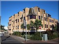
Commerce House, Torquay
This view of Image is from the junction overlooked by Image On the left is Burridge Lane, immediately leading to the view shown in Image
Image: © Derek Harper
Taken: 21 Mar 2008
0.03 miles
8
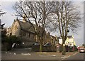
Church of the Assumption of Our Lady, Torquay
The Roman Catholic church dates from 1853 http://list.english-heritage.org.uk/resultsingle.aspx?uid=1279634&searchtype=mapsearch and shares a complex with a presbytery and school (http://list.english-heritage.org.uk/resultsingle.aspx?uid=1202961&searchtype=mapsearch , visible above the telephone box), both also listed. The junction is of Abbey Road with Warren Road (left).
Image: © Derek Harper
Taken: 26 Mar 2013
0.03 miles
9
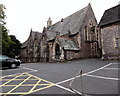
The Church of the Assumption of Our Lady, Torquay
Catholic church on the south side of Abbey Road, at the corner of Warren Road.
The mid 19th century church building was consecrated on February 17th 1854.
Image: © Jaggery
Taken: 4 Jul 2014
0.03 miles
10
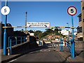
Entrance to car park, Torquay
Burridge Lane, here leading off the traffic lights from Abbey Road, is merely the top entrance to Image (qv for details of the view beyond). On the left should be a footpath leading down steps to Castle Circus, but it is currently closed while work is carried out on a building site to the west of the car park.
Image: © Derek Harper
Taken: 21 Mar 2008
0.03 miles