IMAGES TAKEN NEAR TO
St. Vincents Road, TORQUAY, TQ1 4UP
Introduction
This page details the photographs taken nearby to St. Vincents Road, TQ1 4UP by members of the Geograph project.
The Geograph project started in 2005 with the aim of publishing, organising and preserving representative images for every square kilometre of Great Britain, Ireland and the Isle of Man.

There are currently over 7.5m images from over14,400 individuals and you can help contribute to the project by visiting https://www.geograph.org.uk
Image Map
Images are licensed for reuse under creativecommons.org/licenses/by-sa/2.0
Notes
- Clicking on the map will re-center to the selected point.
- The higher the marker number, the further away the image location is from the centre of the postcode.
Image Listing (1534 Images Found)
Images are licensed for reuse under creativecommons.org/licenses/by-sa/2.0
Image
Details
Distance
1
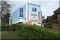
Mobile CT scanner, Mount Stuart Hospital
At the private hospital on St Vincent's Road.
Image: © Derek Harper
Taken: 6 Mar 2016
0.02 miles
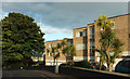
2
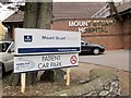
Mount Stuart Hospital
A small private hospital on the tree-lined St Vincent's Road.
Image: © Derek Harper
Taken: 8 May 2009
0.02 miles
3
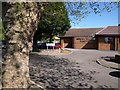
Patient car park, Mount Stuart Hospital
It needs to be - you might have to leave your car here for some time.
Image: © Derek Harper
Taken: 11 Jun 2015
0.03 miles
4
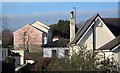
Roofs in Torre
Seen from the path between Stantaway Hill and Stantaway Park. The nearer houses are on Teignmouth Road; at the rear are flats on Chapel Court. With quoins and prominent windows, number 52 Teignmouth Road is listed http://www.britishlistedbuildings.co.uk/en-390805-52-torquay .
Image: © Derek Harper
Taken: 6 Mar 2012
0.03 miles
5

Sunset over Torre
From the path down from Stantaway Hill looking over Teignmouth Road; the flats on the left are on Chapel Court.
Image: © Derek Harper
Taken: 29 Jan 2019
0.03 miles
6
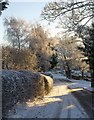
St Vincent's Road, Torquay
A snowy version of the scene in Image, with some delicate birches on the left. On the right is the opening into St Vincent's Close.
Image: © Derek Harper
Taken: 18 Dec 2010
0.04 miles
7
Earl's Court
Not that one, but presumably named after it. This is part of a set of 30 flats on St Vincent's Road.
Image: © Derek Harper
Taken: 4 Aug 2020
0.04 miles
8

Cirrus over Parkhurst Road, Torquay
Mares' tails over the residential road in Torre.
Image: © Derek Harper
Taken: 6 Mar 2018
0.05 miles
9

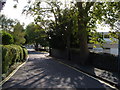
St Vincent's Road, Torquay
A reverse view of Image from the opening of St Vincent's Close (left), with a dog waste bin on the right.
Image: © Derek Harper
Taken: 18 Dec 2010
0.05 miles
10
St Vincent's Road, Torquay
A suburban road linking Barton road with Teignmouth Road in Torre, seen from the junction with Parkhurst Road. The flats on the right are in the vicinity of the site of Agatha Christie's childhood home, demolished in 1962.
Image: © Derek Harper
Taken: 8 Oct 2006
0.05 miles