IMAGES TAKEN NEAR TO
Teignmouth Road, TORQUAY, TQ1 4SJ
Introduction
This page details the photographs taken nearby to Teignmouth Road, TQ1 4SJ by members of the Geograph project.
The Geograph project started in 2005 with the aim of publishing, organising and preserving representative images for every square kilometre of Great Britain, Ireland and the Isle of Man.

There are currently over 7.5m images from over14,400 individuals and you can help contribute to the project by visiting https://www.geograph.org.uk
Image Map
Images are licensed for reuse under creativecommons.org/licenses/by-sa/2.0
Notes
- Clicking on the map will re-center to the selected point.
- The higher the marker number, the further away the image location is from the centre of the postcode.
Image Listing (134 Images Found)
Images are licensed for reuse under creativecommons.org/licenses/by-sa/2.0
Image
Details
Distance
2
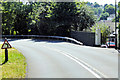
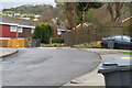
Telecomms boxes, Teignmouth Road
Telecoms boxes on the grass bank opposite Combe Pafford Business and Enterprise School.
Image: © John C
Taken: 29 Mar 2018
0.02 miles

8
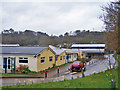
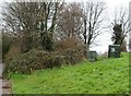
Combe Pafford School
Combe Pafford Business and Enterprise School is a special school which caters for boys and girls aged 6 to 16 who have moderate learning difficulties, physical difficulties or autism. School website: http://www.combepaffordschool.co.uk/ .
Image: © Richard Dorrell
Taken: 26 Mar 2010
0.05 miles
10
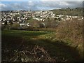
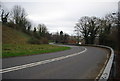
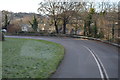
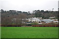
Above Watcombe
Taken nearly 200 metres WSW of the scene in Image, at the far corner of the field shown in Image, and just beyond the track referred to in Image The A379 runs below the further hedge; beyond it are the housing estates of Watcombe. Brunel Woods are on the right.
Image: © Derek Harper
Taken: 23 Jan 2012
0.06 miles