IMAGES TAKEN NEAR TO
Compton Place, TORQUAY, TQ1 4QP
Introduction
This page details the photographs taken nearby to Compton Place, TQ1 4QP by members of the Geograph project.
The Geograph project started in 2005 with the aim of publishing, organising and preserving representative images for every square kilometre of Great Britain, Ireland and the Isle of Man.

There are currently over 7.5m images from over14,400 individuals and you can help contribute to the project by visiting https://www.geograph.org.uk
Image Map
Images are licensed for reuse under creativecommons.org/licenses/by-sa/2.0
Notes
- Clicking on the map will re-center to the selected point.
- The higher the marker number, the further away the image location is from the centre of the postcode.
Image Listing (400 Images Found)
Images are licensed for reuse under creativecommons.org/licenses/by-sa/2.0
Image
Details
Distance
1
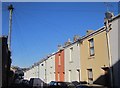
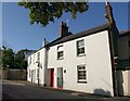
Compton Place, St Marychurch
A terrace of 21 houses on the northeast side of the street.
Image: © Derek Harper
Taken: 19 Jan 2015
0.02 miles
2
Houses on Park Road, St Marychurch
Seen from the little (25 metres long) road linking to Trumlands Road, and which seems to have no name.
Image: © Derek Harper
Taken: 16 Oct 2019
0.04 miles
3
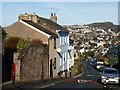
Hartop Road, Torquay
Looking down the road from opposite the entrance to Petitor Mews. In the background, housing between Barton and Watcombe climbs the slopes of Great Hill, with its communications mast.
Image: © Derek Harper
Taken: 27 Jan 2008
0.05 miles
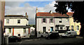
4
Care Home, St Marychurch
Hatt House Residential Home occupies a Victorian villa on Park Road.
Image: © Derek Harper
Taken: 21 Jul 2010
0.05 miles
5
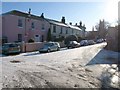
Trumlands Road
Icy conditions on a bend in Trumlands Road, St Marychurch.
Image: © Derek Harper
Taken: 7 Jan 2010
0.06 miles
6
Cambridge Road, Torquay
From close to its junction with Hartop Road, looking past the junction with Hilly Gardens Road on the right.
Image: © Derek Harper
Taken: 25 Apr 2018
0.06 miles
7
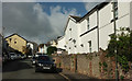
Terrace, Trumlands Road, St Marychurch
The end house at this end is listed: c1840 https://historicengland.org.uk/listing/the-list/list-entry/1219116 .
Image: © Derek Harper
Taken: 16 Oct 2019
0.06 miles
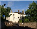
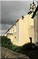
9
Villa, Trumlands Road, St Marychurch
A typical Victorian detached house on a corner by the junction with Havelock Road,
Image: © Derek Harper
Taken: 16 Oct 2019
0.07 miles
10
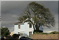
Houses on Park Road, St Marychurch
From beneath a large oak at the junction with Cambridge Road, a view of cottages at the southeast end of a short terrace.
Image: © Derek Harper
Taken: 19 May 2011
0.07 miles