IMAGES TAKEN NEAR TO
Westhill Road, TORQUAY, TQ1 4LT
Introduction
This page details the photographs taken nearby to Westhill Road, TQ1 4LT by members of the Geograph project.
The Geograph project started in 2005 with the aim of publishing, organising and preserving representative images for every square kilometre of Great Britain, Ireland and the Isle of Man.

There are currently over 7.5m images from over14,400 individuals and you can help contribute to the project by visiting https://www.geograph.org.uk
Image Map
Images are licensed for reuse under creativecommons.org/licenses/by-sa/2.0
Notes
- Clicking on the map will re-center to the selected point.
- The higher the marker number, the further away the image location is from the centre of the postcode.
Image Listing (522 Images Found)
Images are licensed for reuse under creativecommons.org/licenses/by-sa/2.0
Image
Details
Distance
1

St Margaret's Mews, Babbacombe
Looking across Westhill Road. Beyond, with the larger balconies, is Image
Image: © Derek Harper
Taken: 2 Nov 2012
0.01 miles
2
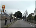
St Margarets Avenue
St Margarets Avenue approaching Westhill Road.
Image: © John C
Taken: 1 Apr 2018
0.02 miles
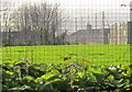
3
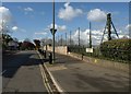
St Margaret's Avenue, Torquay
From its junction with Westhill Road. On the right is a playing field adjoining Homelands Primary School.
Image: © Derek Harper
Taken: 21 Apr 2012
0.02 miles
4
Haytor, Torquay
This little (0.2 hectares) kite-shaped park containing a playground easily escapes notice, as it is entirely surrounded by houses. This view is from the gate leading in from Westhill Road. See also Image
Image: © Derek Harper
Taken: 2 Nov 2012
0.02 miles
5
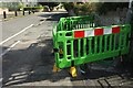
Barrier, St Margaret's Avenue, Torquay
A green barrier with yellow feet guards some electrical pavement work opposite the playing fields of Homelands Primary School.
Image: © Derek Harper
Taken: 22 Jul 2017
0.02 miles
6
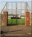
Gate, Homelands Primary School
From St Margaret's Avenue onto a playing field.
Image: © Derek Harper
Taken: 20 Dec 2014
0.03 miles
7
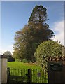
Winter Heliotrope, Westhill Road, Torquay
In flower on the roadside bank alongside Homelands Primary School.
Image: © Derek Harper
Taken: 20 Dec 2014
0.04 miles
8
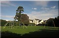
Haytor, Torquay
A view across the little park and playground whose entrance (from the far side) is shown in Image], with climbing frame and swings. The houses are on Westhill Road.
Image: © Derek Harper
Taken: 2 Nov 2012
0.04 miles
9
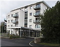
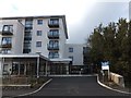
Dunboyne Court, St Marychurch
39 flats of extra care housing, independent living for the elderly with support services. Some are rented, some are shared ownership. See First Stop http://www.housingcare.org/downloads/facilities/generated-brochures/158008-dunboyne-court-st-marychurch-road-england.pdf or Sanctuary Group http://www.sanctuary-group.co.uk/Housing/SharedOwnership/Available%20Properties/Dunboyne%20Court%20Brochure.pdf .
Image: © David Hawgood
Taken: 30 Oct 2011
0.05 miles
10
Newly constructed flats in St Marychurch Road
The picture Image shows these flats being built
Image: © David Smith
Taken: 25 Feb 2012
0.05 miles