IMAGES TAKEN NEAR TO
St. Margarets Avenue, TORQUAY, TQ1 4LN
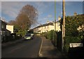
Introduction
This page details the photographs taken nearby to St. Margarets Avenue, TQ1 4LN by members of the Geograph project.
The Geograph project started in 2005 with the aim of publishing, organising and preserving representative images for every square kilometre of Great Britain, Ireland and the Isle of Man.

There are currently over 7.5m images from over14,400 individuals and you can help contribute to the project by visiting https://www.geograph.org.uk
Image Map
Images are licensed for reuse under creativecommons.org/licenses/by-sa/2.0
Notes
- Clicking on the map will re-center to the selected point.
- The higher the marker number, the further away the image location is from the centre of the postcode.
Image Listing (318 Images Found)
Images are licensed for reuse under creativecommons.org/licenses/by-sa/2.0
Image
Details
Distance
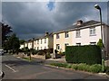
1
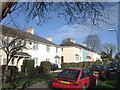
St Margaret's Avenue, Plainmoor
(Probably ex-) local authority housing to the west of Plainmoor.
Image: © Derek Harper
Taken: 12 Jan 2008
0.00 miles
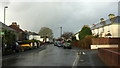
2
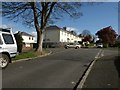
Road junction, Plainmoor
The crossroads of St Margaret's Avenue (the "main" road here) with Westhill Avenue in an area of former local authority housing. Copper beeches have just leaved up the road.
Image: © Derek Harper
Taken: 21 Apr 2012
0.03 miles
3
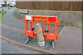
Restrained concrete post, Plainmoor
On the point of breaking free and escaping, this post is being firmly grasped by a plastic barrier.
Image: © Derek Harper
Taken: 27 Feb 2016
0.04 miles
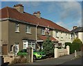
4
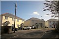
Daison Crescent, Torquay
Houses that postdate most others in the road.
Image: © Derek Harper
Taken: 1 Mar 2014
0.04 miles
5
Westhill Avenue, Torquay
Very similar in character to Image, but with more in the way of trees. Same threatening sky. This is from where a path from Chatto Road emerges.
Image: © Derek Harper
Taken: 13 Jul 2011
0.04 miles
6
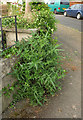
Thistle, Plainmoor
Thus fearsome-looking beast, a spear thistle, is at the corner of Westhill Avenue and St Margaret's Avenue.
Image: © Derek Harper
Taken: 26 May 2018
0.05 miles
7
Westhill Avenue, Torquay
The houses on the right and the junction with Tramways are also shown at Image The footpath sign on the left indicates footpath TQ 61.
Image: © Derek Harper
Taken: 10 Nov 2018
0.05 miles
8
In denial, Plainmoor
I suppose the occupants might still be in Paris following England's ignominious removal from Euro 16, in which case they are more likely to be in Seine rather than in de Nile. Or perhaps it's just stubborn defiance. This is on Westhill Avenue.
Image: © Derek Harper
Taken: 2 Jul 2016
0.05 miles
9
Haytor Road, Torquay
Image shows a reverse view of this short road in Plainmoor connecting St Marychurch Road with St Margaret's Avenue. The cul-de-sac on the right immediately in front of the camera leads to Image
Image: © Derek Harper
Taken: 2 Nov 2012
0.05 miles
10
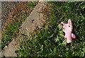
Soft toy, St Margaret's Avenue, Plainmoor
A pig finger puppet on the road side verge.
Image: © Derek Harper
Taken: 3 Jun 2017
0.05 miles