IMAGES TAKEN NEAR TO
St. Vincents Road, TORQUAY, TQ1 4HQ
Introduction
This page details the photographs taken nearby to St. Vincents Road, TQ1 4HQ by members of the Geograph project.
The Geograph project started in 2005 with the aim of publishing, organising and preserving representative images for every square kilometre of Great Britain, Ireland and the Isle of Man.

There are currently over 7.5m images from over14,400 individuals and you can help contribute to the project by visiting https://www.geograph.org.uk
Image Map
Images are licensed for reuse under creativecommons.org/licenses/by-sa/2.0
Notes
- Clicking on the map will re-center to the selected point.
- The higher the marker number, the further away the image location is from the centre of the postcode.
Image Listing (1501 Images Found)
Images are licensed for reuse under creativecommons.org/licenses/by-sa/2.0
Image
Details
Distance
1
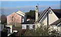
Roofs in Torre
Seen from the path between Stantaway Hill and Stantaway Park. The nearer houses are on Teignmouth Road; at the rear are flats on Chapel Court. With quoins and prominent windows, number 52 Teignmouth Road is listed http://www.britishlistedbuildings.co.uk/en-390805-52-torquay .
Image: © Derek Harper
Taken: 6 Mar 2012
0.02 miles
2

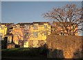
Sunset over Torre
From the path down from Stantaway Hill looking over Teignmouth Road; the flats on the left are on Chapel Court.
Image: © Derek Harper
Taken: 29 Jan 2019
0.02 miles
3
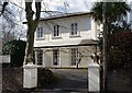
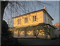
Care home, Teignmouth Road, Torquay
One of a series of nine elegant villas, all listed grade II, along the western side of this stretch of Teignmouth Road, with tented verandahs and quoins. They date from the late 1840s / early 1850s. http://www.imagesofengland.org.uk/Details/Default.aspx?id=390804&mode=adv
Image: © Derek Harper
Taken: 9 Mar 2008
0.03 miles
4
Care home, Teignmouth Road, Torquay
A different angle on the listed care home https://www.historicengland.org.uk/listing/the-list/list-entry/1206843 shown in http://www.geograph.org.uk/search.php?i=68699491 . In the foreground is the junction with Snowberry Close.
Image: © Derek Harper
Taken: 18 Jan 2017
0.03 miles
5
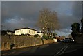
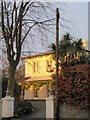
Flats on St Vincent's Road, Torquay
Seen from the junction with Teignmouth Road. The road climbs to the rear of the site of Agatha Christie's childhood home - see Image
Image: © Derek Harper
Taken: 6 Dec 2008
0.04 miles
6
Care home, Teignmouth Road, Torquay
The care home shown in Image is turned yellow by the early morning sun.
Image: © Derek Harper
Taken: 4 Dec 2009
0.04 miles
7
Care home, Teignmouth Road, Torquay
Also shown at Image and Image http://www.imagesofengland.org.uk/Details/Default.aspx?id=390804&mode=adv
Image: © Derek Harper
Taken: 3 Dec 2014
0.04 miles
8
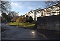
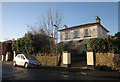
Houses on St Vincent's Road, Torquay
By the junction with Teignmouth Road.
Image: © Derek Harper
Taken: 3 Dec 2014
0.04 miles
9
Villa, Teignmouth Road, Torquay
One http://list.english-heritage.org.uk/resultsingle.aspx?uid=1206844&searchtype=mapsearch of a row of listed villas, similar in design, built in the C19 along the west side of the road.
Image: © Derek Harper
Taken: 15 Jan 2013
0.04 miles
10
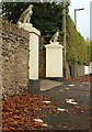
Bread for the eagles
Someone has scattered a sliced white loaf on the pavement of Teignmouth Road, but these gatepost eagles, also seen in Image, are scornful.
Image: © Derek Harper
Taken: 3 Nov 2009
0.04 miles