IMAGES TAKEN NEAR TO
Rowley Road, TORQUAY, TQ1 4FR
Introduction
This page details the photographs taken nearby to Rowley Road, TQ1 4FR by members of the Geograph project.
The Geograph project started in 2005 with the aim of publishing, organising and preserving representative images for every square kilometre of Great Britain, Ireland and the Isle of Man.

There are currently over 7.5m images from over14,400 individuals and you can help contribute to the project by visiting https://www.geograph.org.uk
Image Map
Images are licensed for reuse under creativecommons.org/licenses/by-sa/2.0
Notes
- Clicking on the map will re-center to the selected point.
- The higher the marker number, the further away the image location is from the centre of the postcode.
Image Listing (747 Images Found)
Images are licensed for reuse under creativecommons.org/licenses/by-sa/2.0
Image
Details
Distance
1
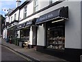
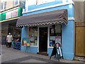
China, glass and gifts shop, St Marychurch precinct
The china shop and the hardware shop next door are in fact all one shop, Drower's at 83 Fore Street. For neighbouring shops see http://www.geograph.org.uk/gallery/st_marychurch_torbay_shops_etc_9887 .
Image: © Joan Vaughan
Taken: 29 Sep 2006
0.01 miles
2
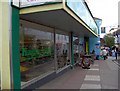
Fruit and grocery shop, St Marychurch precinct
This is Happy Apple at 77 Fore Street. For neighbouring shops see http://www.geograph.org.uk/gallery/st_marychurch_torbay_shops_etc_9887 .
Image: © Joan Vaughan
Taken: 29 Sep 2006
0.01 miles
3
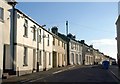
Rowley Road, St Marychurch
Image seen from the junction with Fore Street. The street crosses into Image at around the fourth house past the bend.
Image: © Derek Harper
Taken: 21 Jul 2010
0.01 miles
4
St Marychurch
Pedestrianised shopping street in this small town that is part of the Torbay conurbation.
Image: © Chris Allen
Taken: 2 Apr 2016
0.01 miles
5
Herbs and Honey shop, St Marychurch precinct
This shop http://www.stmarychurch.co.uk/stmarychurch_003.htm is 77 Fore Street. For neighbouring shops see http://www.geograph.org.uk/gallery/st_marychurch_torbay_shops_etc_9887 .
Image: © Joan Vaughan
Taken: 29 Sep 2006
0.01 miles
6
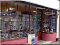
Sweets shop, St Marychurch precinct
This is G L Hockin at 75 Fore Street. For neighbouring shops see http://www.geograph.org.uk/gallery/st_marychurch_torbay_shops_etc_9887 .
Image: © Joan Vaughan
Taken: 29 Sep 2006
0.02 miles
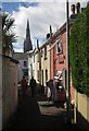
8
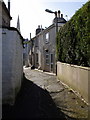
Alley in St Marychurch
This little alley, which seems to have no name (the houses are numbered for Fore Street) runs from the northern end of Chilcote Close to the pedestrian precinct. The spire belongs to Image
Image: © Derek Harper
Taken: 18 Mar 2007
0.02 miles
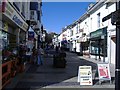
9
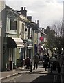
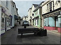
Fore Street, St Marychurch
A busy morning in the pedestrian precinct. View from the junction with Rowley Road.
Image: © Derek Harper
Taken: 2 Nov 2012
0.02 miles
10
Alley, St Marychurch
The address of these cottages in Fore Street, the pedestrianised street in the background. The alley leads from the Chilcote Close car park. The spire belongs to the church of Our Lady, Help of Christians and St Denis.
Image: © Derek Harper
Taken: 30 Aug 2013
0.02 miles