IMAGES TAKEN NEAR TO
TQ1 4BP
Introduction
This page details the photographs taken nearby to TQ1 4BP by members of the Geograph project.
The Geograph project started in 2005 with the aim of publishing, organising and preserving representative images for every square kilometre of Great Britain, Ireland and the Isle of Man.

There are currently over 7.5m images from over14,400 individuals and you can help contribute to the project by visiting https://www.geograph.org.uk
Image Map
Images are licensed for reuse under creativecommons.org/licenses/by-sa/2.0
Notes
- Clicking on the map will re-center to the selected point.
- The higher the marker number, the further away the image location is from the centre of the postcode.
Image Listing (865 Images Found)
Images are licensed for reuse under creativecommons.org/licenses/by-sa/2.0
Image
Details
Distance
1
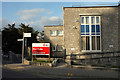
Magistrates' Court for sale, Torquay
An opportunity to feature a somewhat overlooked building, at the corner of Union Street and Trematon Avenue. The court opened in 1960 and closed on 1st September 2017. The majority of cases are now heard in Newton Abbot.
Image: © Derek Harper
Taken: 21 Mar 2018
0.01 miles
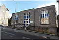
2
Magistrates' Court for sale, Torquay
Another shot of the building shown in Image]; whatever becomes of it, it seems unlikely to retain its current appearance.
Image: © Derek Harper
Taken: 21 Mar 2018
0.01 miles
3
Torquay Magistrates' Court
Entrance viewed across Union Street. Castle Chambers http://www.geograph.org.uk/photo/4064148 are on the left.
Image: © Jaggery
Taken: 5 Jul 2014
0.02 miles
4
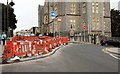
Reversing the flow, Torquay
On 11th April, the flow of traffic along Union Street between Trematon Avenue (right here) and Laburnum Row, was reversed. For the previous three decades, it was a one-way street heading out of town; now traffic heads inwards. The new works in the foreground force traffic to turn right into Trematon Avenue. On the other side of the junction is Castle Chambers Image
Image: © Derek Harper
Taken: 25 Apr 2016
0.02 miles
5
Reversing the flow, Torquay
Another view of the new paving works diverting traffic, shown in Image In the background here is the Magistrates' Court Image
Image: © Derek Harper
Taken: 25 Apr 2016
0.02 miles
6
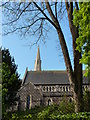
St Mary Magdalene, Upton Church, Torquay
A view of the church from the access lane which descends behind the Lymington Road car park.
Image: © Tom Jolliffe
Taken: 3 May 2010
0.02 miles
7
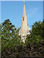
Spire, St Mary Magdalene, Upton Church
One wonders why the church was named St Mary Magdalene? Given that Torquay was a holiday resort which may have attracted men and women of "easy virtue", this church might have been a silent reminder that redemption was available to such sinners, not only redemption, but elevation to beatitude. The spire is a fine one, pointing to the heavens and personifying rectitude.
There were protests at the plan to build a second hotel in Torquay as it was argued that it would affect the moral character of the town. The population doubled in ten years between 1841 and 1851 from over five thousand to over ten thousand.
Image: © Tom Jolliffe
Taken: 3 May 2010
0.02 miles
8
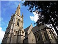
St Mary Magdalene, Upton Church, Torquay
This fine church is described in Image Additional information: "The church was originally built to the designs of Anthony Salvin by Jacob Harvey (one of two builder brothers responsible for much of Torquay’s mid-Victorian development) in 1848-49 using coursed Torquay limestone rubble with dressings of Bath stone. The first of Torquay’s new parish churches its style, especially nave, tower and spire, is essentially Early English; the south transept tower and spire was completed in 1862.
Salvin’s originally relatively plain work, is countered by an ornate High Victorian scheme – the work of Giles Gilbert Scott who altered and partly refitted the chancel in 1882 (riotous Pevsner) – and further early-20th century fittings which including Devonshire marbles, and an alabaster reredos, added in 1906, and in 1927 the date of the north-east chapel." Upton Conservation Area
Character Appraisal - Torbay Council 2005 http://www.brixhamtowncouncil.gov.uk/upton_area_appraisal.pdf
Image: © Tom Jolliffe
Taken: 3 May 2010
0.02 miles
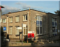
9
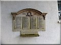
War memorial near St Mary Magdalene, Torquay
This memorial is on the wall of the hall by the church. It refers to "This school" but does not name it. It was Upton National School and was originally where the Magistrates Court stands today Image In fact when the school was demolished the court building was built on the old foundations. The war memorial was later relocated to the external wall of the parish hall in 1956. The names are all in alphabetical order except for the addition of Alford, C at the end of the first column, Bowden, CJ, Blackler, J, and Palmer, P. As Alford and Palmer were clearly afterthoughts, I wonder why their names have not been repainted. And was Blackler's name added, and then removed? It has not been repainted, although Bowden's has. My thanks to fellow Geograph-er JohnC who added the information about the school and the court building.
Image: © David Smith
Taken: 19 Feb 2013
0.02 miles
10
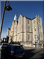
Castle Chambers, Torquay
This imposing Victorian limestone building on Higher Union Street, with a little octagonal turret, formerly housed the County Court offices. "1850 in origin, brought "up to date" 1892-93 ... Snecked local grey limestone with Bathstone and limestone ashlar dressings; gabled slate roofs." http://www.imagesofengland.org.uk/Details/Default.aspx?id=390866&mode=adv
It now has a variety of uses and occupants - there are flats, a language school, social organisations, and businesses.
Image: © Derek Harper
Taken: 26 Jan 2008
0.02 miles