IMAGES TAKEN NEAR TO
Whitear Close, TEIGNMOUTH, TQ14 9UU
Introduction
This page details the photographs taken nearby to Whitear Close, TQ14 9UU by members of the Geograph project.
The Geograph project started in 2005 with the aim of publishing, organising and preserving representative images for every square kilometre of Great Britain, Ireland and the Isle of Man.

There are currently over 7.5m images from over14,400 individuals and you can help contribute to the project by visiting https://www.geograph.org.uk
Image Map (Loading...)


Getting Data...Please wait
Leaflet Map data © OpenStreetMap
Images are licensed for reuse under creativecommons.org/licenses/by-sa/2.0
Notes
- Clicking on the map will re-center to the selected point.
- The higher the marker number, the further away the image location is from the centre of the postcode.
Image Listing (69 Images Found)
Images are licensed for reuse under creativecommons.org/licenses/by-sa/2.0
Image
Details
Distance
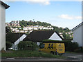
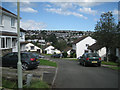
1
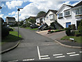
Whitear Close, off Moor View Drive, Teignmouth
Image: © Robin Stott
Taken: 19 Aug 2012
0.01 miles
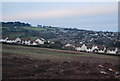
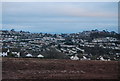
5
Meadow Rise, off Moor View Drive, Teignmouth
With foreground in shadow, attention is drawn to the other side of the Coombe valley: prominent are the big blocks at the north end of Deer Park Avenue and Harts Close upslope behind them Image
Image: © Robin Stott
Taken: 19 Aug 2012
0.05 miles
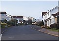
7
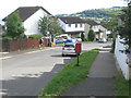
Down Moor View Drive (3), Teignmouth
Postbox TQ14 57. The hill above Shaldon, across the Teign, is still in view.
Image: © Robin Stott
Taken: 19 Aug 2012
0.06 miles
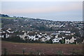
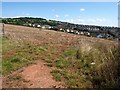
8
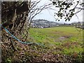
The view from Shepherds Lane
A view from opposite Higher Coombe Farm, looking over a field to the housing development around Moorview Drive
Image: © David Smith
Taken: 14 Feb 2012
0.07 miles
9
Meadow Rise, off Moor View Drive, Teignmouth
In shadow in the distance, the tiers of houses climb the steep Coombe valley sides.
Image: © Robin Stott
Taken: 19 Aug 2012
0.08 miles
10
Coombe, Teignmouth
This view includes the housing shown in Image, and is also taken from Shepherds' Lane. The crop in the foreground has now been harvested. Beyond, above housing in SX9374, is Holcombe Down.
Image: © Derek Harper
Taken: 22 Aug 2008
0.08 miles