IMAGES TAKEN NEAR TO
The Orchard, TEIGNMOUTH, TQ14 9RB
Introduction
This page details the photographs taken nearby to The Orchard, TQ14 9RB by members of the Geograph project.
The Geograph project started in 2005 with the aim of publishing, organising and preserving representative images for every square kilometre of Great Britain, Ireland and the Isle of Man.

There are currently over 7.5m images from over14,400 individuals and you can help contribute to the project by visiting https://www.geograph.org.uk
Image Map
Images are licensed for reuse under creativecommons.org/licenses/by-sa/2.0
Notes
- Clicking on the map will re-center to the selected point.
- The higher the marker number, the further away the image location is from the centre of the postcode.
Image Listing (103 Images Found)
Images are licensed for reuse under creativecommons.org/licenses/by-sa/2.0
Image
Details
Distance
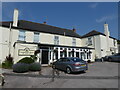
2
Corner of Cockhaven Road and The Orchard, Bishopsteignton
Image: © David Gearing
Taken: 3 Feb 2011
0.09 miles
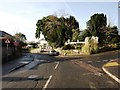
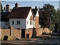
3
Shute Hill
Note the blocked up doorway. I wonder where it went?
Image: © Anthony Vosper
Taken: 9 Jul 2011
0.09 miles
4
Green, Bishopsteignton
Seventeenth century house with later alterations and additions https://historicengland.org.uk/listing/the-list/list-entry/1147732?section=official-list-entry
Image: © Jonathan Thacker
Taken: 15 Jun 2024
0.10 miles
5
Shute Hill, Bishopsteignton
This large house is on the east side of the hill, which drops from the centre of the village.
Image: © Derek Harper
Taken: 26 Sep 2008
0.10 miles
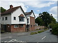
6
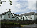
Bishopsteignton Community Centre and Museum
A fromer school https://historicengland.org.uk/listing/the-list/list-entry/1333902?section=official-list-entry
Image: © Jonathan Thacker
Taken: 15 Jun 2024
0.11 miles
7
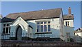
Community Centre, Bishopsteignton
Overlooking Shute Hill, this is just part (dated 1850) of the centre, which includes the Bishopsteignton Museum of Rural Life.
Image: © Derek Harper
Taken: 26 Sep 2008
0.11 miles
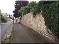
8
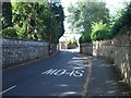
Church Road, Bishopsteignton
The churchyard wall is on the right.
Image: © David Smith
Taken: 12 Sep 2010
0.11 miles
9
Bishopsteignton
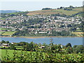
Bishopsteignton is a large village on the north bank of the Teign Estuary, 1-2 miles west of Teignmouth - viewed here from the south above Ringmore.
Image: © Colin Smith
Taken: 18 Jul 2021
0.11 miles
10
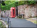
Telephone box, Bishopsteignton
K6 type telephone box on Fore Street.
Image: © Maigheach-gheal
Taken: 14 May 2009
0.11 miles